 |
 |
 |
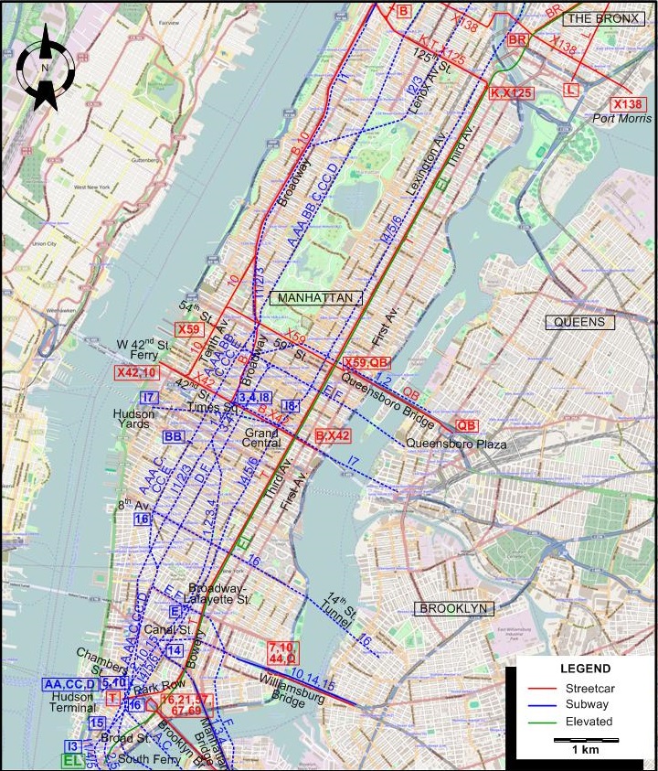
Because of the complexity of the New York streetcar and subway network, there are four maps showing the routes:
- A map showing Manhattan
- A map showing The Bronx
- A map showing Brooklyn & Queens
- A map showing Downtown Brooklyn
FIRST MAP: MANHATTAN (except for Upper Manhattan)
SECOND MAP: THE BRONX (including Upper Manhattan)
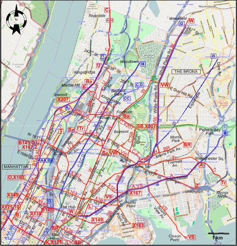
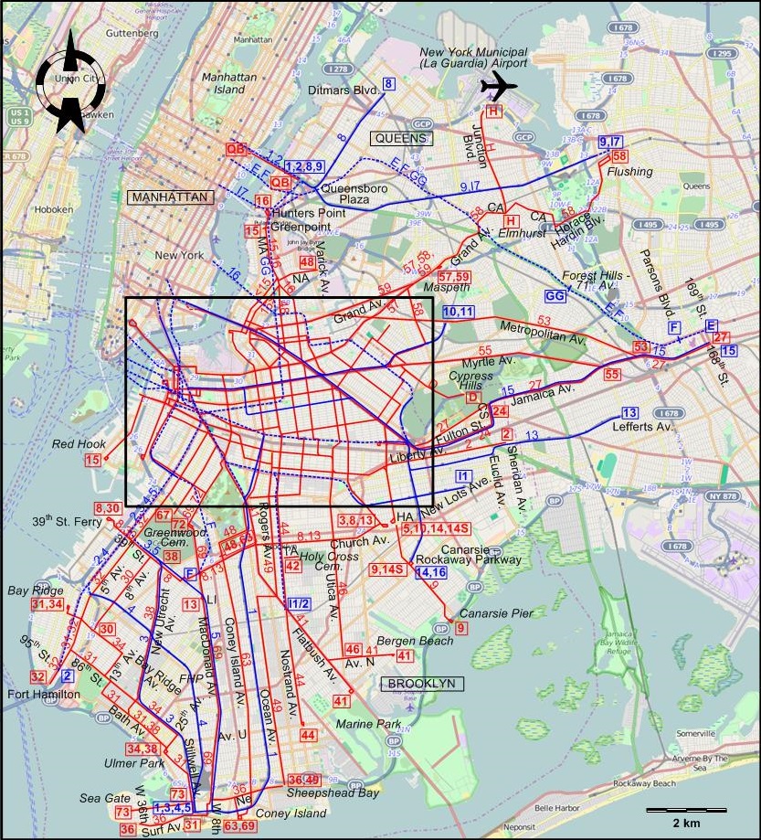
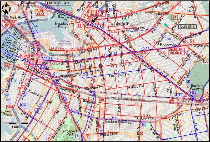
I created the above maps by overlaying OpenStreetMap (OSM) maps with my own data. Copyright on the OSM maps is © OpenStreetMap contributors, licensed under a CC-BY-SA (Creative Commons Attribution-ShareAlike 2.0 licence).
Please note that the OSM maps used as templates for these maps correspond to the situation at the time the maps were downloaded and may show features that did not exist at the time the GS Tram Site is supposed to show. In particular, they may show bridges and highways that were built later.
ABBREVIATIONS ON THE MAPS
BROOKLYN
| BH | (Brooklyn) Borough Hall | LI | Long Island RR Interchange |
| CA | Corona Ave. | MA | Manhattan Av. |
| CS | Crescent Street | NA | Nassau Av. |
| FHP | Fort Hamilton Park | Ne | Neptune Av. |
| HA | Hegeman Av. | TA | Tilden Av. |
| HS | Hoyt–Schermerhorn Streets | WP | Williamsburg Plaza |
| JS | Joyce St. |
MANHATTAN
| EF | Edgewater Ferry |
ROUTES
Operator: New York City Board of Transportation
STREETCAR ROUTES
THE BRONX (and some lines extending into Manhattan)
| A | Westchester Av. | The Hub - Westchester Av. - Westchester Sq. |
| Ba* | Bailey Av. | Kingsbridge - Bailey Av. - Fordham Rd. - Fordham |
| BR* | Boston Rd. | Mott Haven - The Hub - Boston Rd. - West Farms Sq. - Morris Park Av. - Morris Park |
| C | Bronx & Van Cortlandt Parks Crosstown | West Farms Sq. - E 180th St. - Southern Blvd. - Fordham Rd. - Kingsbridge Rd. - Broadway - Riverdale (City Line) |
| L | St. Ann's Ave. | Mott Haven - St. Ann's Ave. - E 161st St. |
| O | Ogden Av. | Amsterdam Av. - W 155th St. - Ogden Av. - Washington Br. - Broadway |
| SB* | Southern Blvd. | Mott Haven - Southern Blvd. - Belmont |
| Se* | Sedgwick Av. | Sedgwick Av. - Burnside Av. - Tremont Av. - 3rd Av. |
| Tr* | Tremont Av. | University Av. - Burnside Av. - Tremont Av. - West Farms Sq. - Tremont Av. - Throgs Neck |
| U | University Av. | Broadway - Washington Br. - University Av. - Kingsbridge Rd. - Sedgwick Av. - 238th St. - Kingsbridge |
| VS* | Sound View Av. | Hunts Point - Westchester Av. - Sound View Av. - Clason Point |
| VW* | Williamsbridge | 3rd Av. - Tremont Av. - West Farms Sq. - Morris Park Av. - White Plains Rd. - E Gun Hill Rd. |
| W | Webster & White Plains Avenues | The Hub - Melrose Av. - Webster Av. - White Plains Rd. - Wakefield (City Line) |
| X138** | 138th St. Crosstown | 8th Av. (Manhattan) - W 135th St. - Madison Av. - E 138th St. (Bronx) - Port Morris |
* Some lines shared their letter designations (B, S, T, V). In these cases, I added a second letter for clarity.
** There was one crosstown line designated with the letter X. For clarity, I added 138 to it (since it was also known as the 138th Street line).
BROOKLYN (and some lines extending to Manhattan and Queens)
| 2 | Bergen St. | Sackett St. - Smith St. - Bergen St. - St. Johns Pl. - Liberty Av. - Sheridan Av. |
| 3 | Sumner Ave. | Williamsburg Plaza - Broadway - Sumner Av. (Marcus Garvey Blvd.) - St. Johns Pl. - Hegeman Av. |
| 5 | St Johns Place | Borough Hall - Livingston St. - Atlantic Av. - Washington Av. - St Johns Place - Rockaway Ave. - Hegeman Av. |
| 7 | Tompkins Av. | Delancey Underground (Manhattan) - Williamsburg Bridge - Williamsburg Plaza - Tompkins Av. - Kingston Av. - Empire Blvd. - Prospect Park |
| 8 | Church Av. | 39th St. Ferry - 39th St. - Church Av. - Hegeman Av. |
| 9 | Rockaway Parkway | Canarsie–Rockaway Parkway - Canarsie Pier |
| 10 | Ralph & Rockaway Avenues | Delancey Underground (Manhattan) - Williamsburg Bridge - Williamsburg Plaza - Broadway - Ralph Av. - E New York Av. - Rockaway Ave. - Hegeman Av. |
| 13 | Gravesend & Church Avenues | Long Island RR Interchange - MacDonald Av. - Church Av. - Hegeman Av. |
| 14 | Wilson Av. | Williamsburg Plaza - Meserole St. [back: Johnson Av. - Broadway] - Johnson Av. - Wilson Av. - Cooper St. - Rockaway Ave. - Hegeman Av. |
| 14S | Wilson Av. Shuttle | Hegeman Av. - Rockaway Ave. - Canarsie–Rockaway Parkway |
| 15 | Crosstown | Greenpoint - Manhattan Av. - Bedford Av. [back: Driggs Av.] - Broadway Ferry - Wythe Av. - Flushing Av. - Vanderbilt Av. - Myrtle Av. - Willoughby St. - Court St. - Atlantic Av. - Columbia St. - Red Hook |
| 16 | Graham Av. | Hunters Point (Queens) - Manhattan Av. - Flushing Av. - Brooklyn Bridge - Park Row (Manhattan) |
| 21 | DeKalb Av. | Park Row (Manhattan) - Brooklyn Bridge - Adams St. - Willoughby St. - DeKalb Av. - Stanhope St. / Seneca Av. (to Myrtle Av.) |
| 24 | Broadway | Williamsburg Plaza - Broadway - Fulton St. - Crescent St. - Cypress Hills |
| 26 | Putnam Av. | Borough Hall - Livingston St. - Lafayette Av. - Fulton St. - Putnam Av. - Nostrand Av. - Halsey St. - Cypress Av. - Ridgewood (Queens) |
| 27 | Jamaica Av. | Hopkinson Av. (Thomas S. Boyland St.) - Fulton St. - Jamaica Av. - 168th St. (Queens) |
| 30 | Eighth Av. | 39th St. Ferry - 39th St. - 8th Av. - Bay Ridge Av. |
| 31 | 86th St. | Bay Ridge - Bay Ridge Av. - 5th Av. - 86th St. - 14th Av. - Bath Av. - 25th Av. - Ulmer Park - Stillwell Av. - Coney Island |
| 32 | 5th Av. | South Ferry - Atlantic Av. - 5th Av. - Fort Hamilton |
| 34 | Bay Ridge Av. | Bay Ridge - Bay Ridge Av. - 13th Av. - 86th St. - 25th Av. - Ulmer Park |
| 36 | Sea Gate (Surf Ave.) | Coney Island (W 36th St. - Surf Av. - W 8th St. - Neptune Av. - Sheepshead Bay) |
| 38 | West End (Utrecht Av.) | Greenwood Cemetary - New Utrecht Av. - Bath Av. - Ulmer Park |
| 41 | Flatbush Av. | Court St. - Livingston St. - Flatbush Av. - Marine Park [Branch: Flatbush Av. - Av. N - Bergen Beach] |
| 42 | Holy Cross Cemetery | Nostrand Av. - Tilden Av. - Holy Cross Cemetery |
| 44 | Nostrand Av. | Delancey Underground (Manhattan) - Williamsburg Bridge - Williamsburg Plaza - Lee Av. - Nostrand Av. - Av. U |
| 46 | Utica & Reid Avenues | Williamsburg Plaza - Broadway - Reid Av. (Malcolm X Blvd.) - Utica Av. - Av. N |
| 48 | Lorimer St. | Varick Av. - Nassau Av. - Lorimer St. - Flushing Av. - Franklin Av. - Prospect Park - Church Av. |
| 49 | Ocean Av. | Bergen St. - Rogers Av. - Ocean Av. - Sheepshead Bay |
| 50 | Bushwick Av. | Williamsburg Plaza - Meserole St. [back: Johnson Av. - Broadway] - Bushwick Av. - Myrtle Av. - Ridgewood (Queens) |
| 53 | Metropolitan Av. | Williamsburg Plaza - Grand St. - Metropolitan Av. - Jamaica Av. |
| 54 | Myrtle Av. & Court St. | Red Hook - Court St. - Myrtle Av. - Ridgewood (Queens) |
| 55 | Richmond Hill | Ridgewood (Queens) - Myrtle Av. - Jamaica Av. |
| 57 | Flushing Av. | Park Row (Manhattan) - Brooklyn Bridge - Flushing Av. - Grand Av. - Maspeth |
| 58 | Flushing - Ridgwood | Ridgewood (Queens) - Palmetto St. - Fresh Pond Rd. - Grand Av. - Corona Ave. - Horace Hardin Blv. - Flushing |
| 59 | Grand St. | Williamsburg (Broadway) - Driggs Av. [back: Bedford Av.] - Grand St. - Grand Av. - Maspeth |
| 63 | Coney Island Ave. | Church Av. - Coney Island Ave. - Coney Island |
| 67 | Seventh Av. | Park Row (Manhattan) - Brooklyn Bridge - Joyce St. - Livingston St. - Flatbush Av. - 7th Av. - Greenwood Cem. |
| 69 | MacDonald - Vanderbilt Avenues | Park Row (Manhattan) - Brooklyn Bridge - Flushing Av. - Vanderbilt Av. - Prospect Park W. - MacDonald Av. - Coney Island |
| 72 | Smith St. | Brooklyn Bridge - Joyce St. - Smith St. - 9th St. - Prospect Park W. - Greenwood Cem. |
| 73 | Norton's Point | Sea Gate - Coney Island (Stillwell Av.) |
| D | Cypress Hills Cemetery | Ridgewood - Cypress Av. - Cypress Hills Cemetery |
| H | Junction Blvd. | Elmhurst (Queens) - Junction Blvd. - New York Municipal (La Guardia) Airport |
| Q | Williamsburg Bridge Local | Delancey Underground (Manhattan) - Williamsburg Bridge - Williamsburg Plaza |
MANHATTAN
| B | Broadway | First Av. - 42nd St. - Times Sq. - Broadway - Amsterdam Av. - W 129th St. |
| K | Broadway, Amsterdam Av. & 125 St. | Third Av. - 125th St. - Amsterdam Av. - Broadway - Marble Hill |
| T | Third & Amsterdam Av. | Park Row - Bowery - Third Av. - 125th St. - Amsterdam Av. - 190th St. |
| X42 | 42nd St. Crosstown | First Av. - 42nd St. - Times Sq. - 42nd St. - W 42nd St. Ferry |
| 10 | Tenth Av. | W 42nd St. Ferry - 42nd St. - Tenth Av. - Broadway - Edgewater Ferry |
| X59 | 59th St. Crosstown | Queensboro Bridge - 59th St. - Tenth Av. - 54th St. |
| X125 | 125th St. Crosstown | Third Av. - 125th St. - Edgewater Ferry |
Note: Crosstown routes were simply designated as X. The designations X42, X59 and X125 are used for clarity.
QUEENSBOROUGH BRIDGE LINE
Operated by Queensborough Traction
| QB | Queensborough Bridge Railway | 59th St. & 2nd Av. - Queensboro Bridge - Queensboro Plaza (Queens) |
Note: The QB designation above is for clarity, and was not used by the operator.
SUBWAY LINES
Note: Subway routes in New York City sometimes varied in function of the day of the week, time of day and other factors. In the list below, I tried to present the normal weekday operation for each route.
BMT LINES
| 1 | Q | Brighton Beach Line | Queensboro Plaza (Queens) - Times Square (Manhattan) - Manhattan Bridge - Stillwell Av. (Brooklyn) |
| 2 | R | Fourth Ave. Line | Queensboro Plaza (Queens) - Times Square (Manhattan) - Montague St. Tunnel - 4th Ave. (Brooklyn) - Bay Ridge 95th St. (Brooklyn) |
| 3 | T | West End Line | Times Square (Manhattan) - Manhattan Bridge - 4ht Ave. (Brooklyn) - New Utrecht Av. - 86th St. - Stillwell Av. (Brooklyn) |
| 4 | N | Sea Beach Line | Times Square (Manhattan) - Manhattan Bridge - 4th Av. (Brooklyn) - Fort Hamilton Park - Stillwell Av. (Brooklyn) |
| 5 | SS | Culver Line | Chambers Street (Manhattan) - Montague St. Tunnel - 4th Av. (Brooklyn) - MacDonald Av. - Stillwell Av. (Brooklyn) |
| 7 | SS | Franklin Ave. Shuttle | Franklin Av. Station (Brooklyn) - Prospect Park (Brooklyn) |
| 8 | - - | Astoria Line | Queensboro Plaza (Queens) - Ditmars Blvd. (Queens) |
| 9 | 7 | Flushing Line | Queensboro Plaza (Queens) - Flushing (Queens) |
| 10 | M | Myrtle Av. - Chambers St. Line | Chambers Street (Manhattan) - Williamsburg Bridge - Broadway (Brooklyn) - Myrtle Av. - Metropolitan Av. (Queens) |
| 11 | MJ | Myrtle Av. Line | Downtown Brooklyn (Bridge / Jay Streets) - Myrtle Av. - Metropolitan Av. (Queens) |
| 12 | - - | Lexington Av. Line | Downtown Brooklyn (Bridge / Jay Streets) - Myrtle Av. - Lexington Av. - Broadway - Eastern Parkway (Brooklyn) |
| 13 | - - | Fulton St. Line | Rockaway Av. (Brooklyn) - Lefferts Av. (Queens) |
| 14 | K | Broadway (Brooklyn) Line | Canal Street (Manhattan) - Williamsburg Bridge - Broadway (Brooklyn) - Canarsie Rockaway Parkway |
| 15 | J | Jamaica Line | Broad Street (Manhattan) - Williamsburg Bridge - Broadway (Brooklyn) - Jamaica Av. - 168th St. (Queens) |
| 16 | L | 14th St. Canarsie Line | 14th St. 8th Av. (Manhattan) - 14th St. Tunnel - Eastern Parkway (Brooklyn) - Canarsie Rockaway Parkway |
Line numbers (in the first column) are those used by the operator in 1946. Letters (in the second column) indicate the letters used today for the same (or similar) route in the New York City transit system.
IND LINES
| A | IND | W 207th St. (Manhattan) - Rockaway Av. (Brooklyn) |
| AA | IND | Hudson Terminal (Manhattan) - W 168th St. (Manhattan) |
| BB* | IND | 34th Street / Herald Square (Manhattan) - W 168th St. (Manhattan) |
| C | IND | 205th St. (Bronx) - Hoyt–Schermerhorn Streets (Brooklyn) |
| CC* | IND | Bedford Park (Bronx) - Hudson Terminal (Manhattan) |
| D | IND | Hudson Terminal (Manhattan) - 205th St. (Bronx) |
| E | IND | Broadway-Lafayette St. (Manhattan) - 169th St. (Queens) |
| F | IND | Parsons Blvd. (Queens) - Church Av. (Brooklyn) |
| GG | IND | Forest Hills - 71st Av. (Queens) - Smith 9th Streets (Brooklyn) |
* Rush hour service only
Single-lettered lines were express (at least partly), while double-lettered lines were always local (i.e. stopping at all stations).
IRT LINES
| I1 | 1 | Broadway - 7th Ave. - Brooklyn (Local & Express) | 242nd St. (Bronx) - Broadway - 7th Ave. (Manhattan) - Joralemon St. Tunnel - Flatbush Av. (Brooklyn) - Eastern Parkway - New Lots Ave. (Brooklyn) / Flatbush Av. (Brooklyn) |
| I2 | 2 | 7th Ave. Express | 241st St. (Bronx) - White Plains Rd. (Bronx) - Westchester Av. (Bronx) - Lenox Av. (Malcolm X Blvd.) (Manhattan) - Broadway - 7th Ave. (Manhattan) - Clark St. Tunnel - Flatbush Av. (Brooklyn) - Eastern Parkway - Flatbush Av. (Brooklyn) |
| I3 | 3 | 7th Ave. Express | 145th St. (Bronx) - Lenox Av. (Malcolm X Blvd.) (Manhattan) - Broadway - 7th Ave. (Manhattan) - South Ferry |
| I4 | 4 | Jerome Av. - Lexington Av. Express | Woodlawn (Bronx) - Jerome Av. (Bronx) - Lexington Av. (Manhattan) - Joralemon St. Tunnel - Flatbush Av. (Brooklyn) - Eastern Parkway - Utica Av. (Brooklyn) |
| I5 | 5 | Dyre Av. - Lexington Av. Express | Dyre Av. (Bronx) - Esplanade (Bronx) - Westchester Av. (Bronx) - Lexington Av. (Manhattan) - Joralemon St. Tunnel - Flatbush Av. (Brooklyn) - Atlantic Av. (Brooklyn) |
| I6 | 6 | Lexington Av. Pelham (Local & Express) | Pelham Bay Park (Bronx) - Westchester Av. (Bronx) - Lexington Av. (Manhattan) - Brooklyn Bridge City Hall |
| I7 | 7 | Flushing (Local & Express) | Hudson Yards (Manhattan) - Times Square - Grand Central - Hunters Point (Queens) - Queensboro Plaza (Queens) - Flushing (Queens) |
| I8 | S | 42nd St. Shuttle | Times Square (Manhattan) - Grand Central (Manhattan) |
IRT Line indicators (I1 etc.) as given above are for clarity, and were not used by the operator. The number part tends to correspond to their number designation today, which are given in the second column.
ELEVATED RAILROAD LINES
(Part of the IRT system)
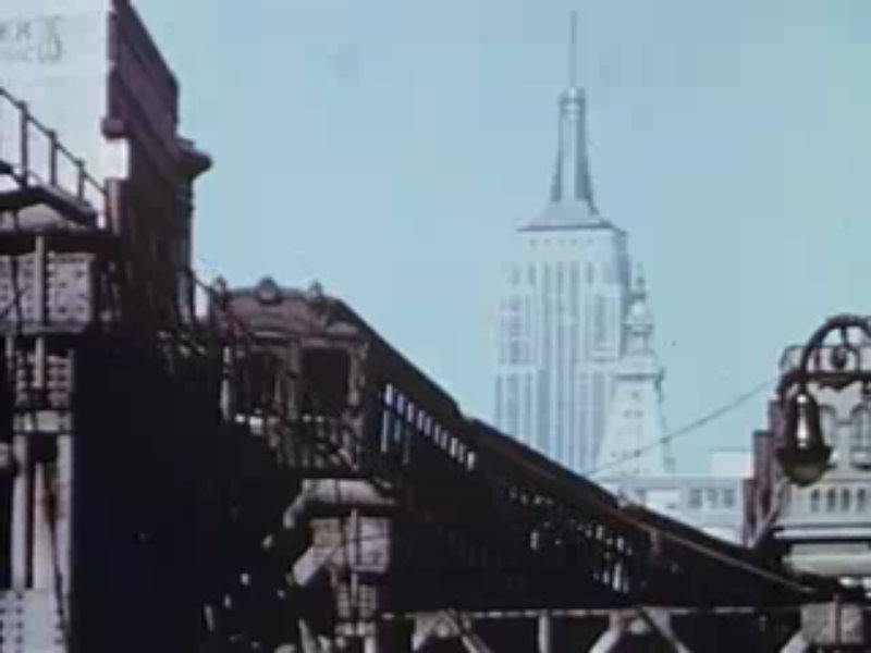
| EL | Third Ave. El | South Ferry (Manhattan) - Third Ave. (Manhattan and the Bronx) - E Gunn Hill Road (The Bronx) |
CHARACTERISTICS OF THE SYSTEM
NETWORK LENGTH
- Streetcar lines: ? km.
- Queensboro Railway: 3 km.
- Subway: ca. 400 km.
- Elevated line: ? km.
HISTORY
- Horse-drawn streetcars: (Manhattan & The Bronx) 1853 - 1899; (Brooklyn) 3 July 1854 - 1893.
- Electric streetcars (Manhattan, conduit system): 1899 - 1 July 1947.
- Electric streetcars (The Bronx) 1899 - 21 Aug. 1948 ; (Brooklyn and Queens): 1893 - 31 Oct. 1956.
- Queensborough Bridge Railway: 1909 - 7 Apr. 1957.
- Subway: 27 Oct. 1904 (but first overground component of the later subway system: 8 June 1864 - ) - today.
- Elevated railway (Manhattan & Bronx): 1 July 1868 - Apr. 1973.
GAUGE
- Manhattan streetcars: 1435 mm.
- Subways & Elevated lines: 1435 mm.
TRAM PRESERVATION
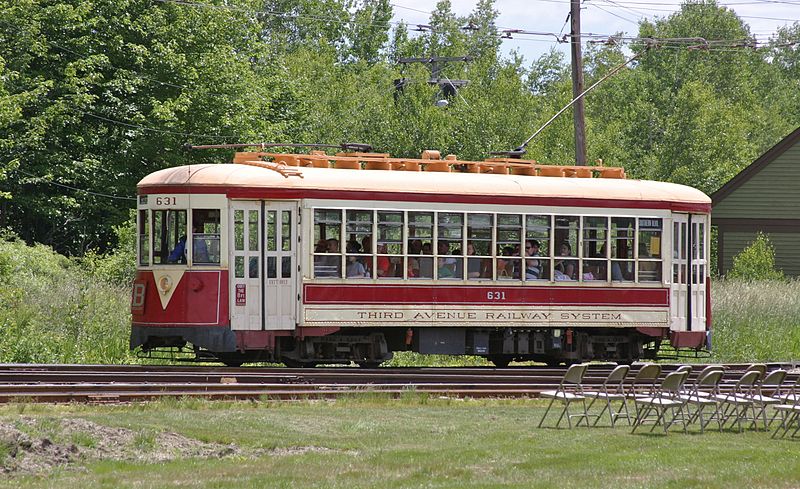
The Trolley Museum of New York (in Kingston NY, 146 km north of New York City in the Hudson Valley) runs heritage stretcars in the summer season on ca. 25 km of track.
SOURCES
- Ballard, C.L. Images of Rail: Metropolitan New York's Third Avenue Railway System. Charleston, SC: Arcadia Publishing, 2005
- Branfors Electric Railway Association Images of Rail: Brooklyn streetcars. Charleston, SC: Arcadia Publishing, 2008
- Byford, A. "‘Train Daddy’ and the Big Apple", Tramways & Urban Transit, Nov. 2024 (87: 1043), p.418-420.
- Meyers, S.L. Images of Rail: Lost trolleys of Queens and Long Island. Charleston, SC: Arcadia Publishing, 2006
- Meyers, S.L. Images of Rail: Manhattan's lost streetcars. Charleston, SC: Arcadia Publishing, 2005
- Taplin, M.R. Tramways of North America, including rapid transit [Tramway Handbooks No.4]. Hassocks (West Sussex, England): Light Rail Transit Association, 1981.
- Track map of Brooklyn, Surface Lines Division, N.Y City Transit System. Hoboken, NJ: Electric Railroaders Association, 1946 (reissued 1950).
- Trackage map, Third Avenue Transit System: Lines in Manhattan below 125th Street. Hoboken, NJ: Electric Railroaders Association, 1946.
- Trackage map, Third Avenue Transit System: Lines in Upper Manhattan and the Bronx. Hoboken, NJ: Electric Railroaders Association, 1946.
- Volkmer, W.D. New York City Trolleys in Color. Flemington, NJ: Morning Sun Books, 2002.
WIKIS
- Brooklyn–Manhattan Transit Corporation (BMT)
- Interborough Rapid Transit Company
- IRT Third Avenue Line
- List of streetcar lines in Brooklyn
- List of streetcar lines in Manhattan
- List of streetcar lines in Queens
- List of streetcar lines in the Bronx
- MTA Regional Bus Operations
- New York City Omnibus Corporation
- New York City Subway
- New York City Subway nomenclature
- New York Transit Museum
- Rapid transit operations of the BRT and BMT
- Third Avenue Railway
- Trolley Museum of New York
WEB SITES
- MTA
- New York City (on UrbanRail.Net)
- New York Transit Museum
- Time traveling on the 3rd Ave. El
- Trolley Museum of New York
- www.nycsubway.org/
Special thanks to Bob Townley of Fairfield, CA for supplying me with much of the material used for the creation of this page, and for his kind suggestions for improving it.
Special thanks also to Russell Powers for information on the Queensboro railway.
Copyright Gabor Sandi 1998-2026
Disclaimer: Everything on this site was written and/or prepared at the author's discretion. The author has tried to be accurate where facts are presented, but this does not mean that these facts are necessarily accurate. People needing more reliable information should refer to appropriate sources presented, on the Internet or elsewhere, by authoritative professional or academic bodies.
To get in touch with the webmaster, send an e-mail to g_sandi at hotmail.com.
Flags on this site are from the FOTW Flags Of The World website.