VIDEOS
 |
 |
| Above: YouTubeCA video - Cleveland's Public Square during the evening Rush Hour - Length: 3:23 mins. | Above: YouTubeCA video - Shaker Heights Rapid Transit And More (Circa 1960) - Length: 36:26 mins. |
PHOTOS
 |
 |
MAPS
INSET: CENTRAL CLEVELAND
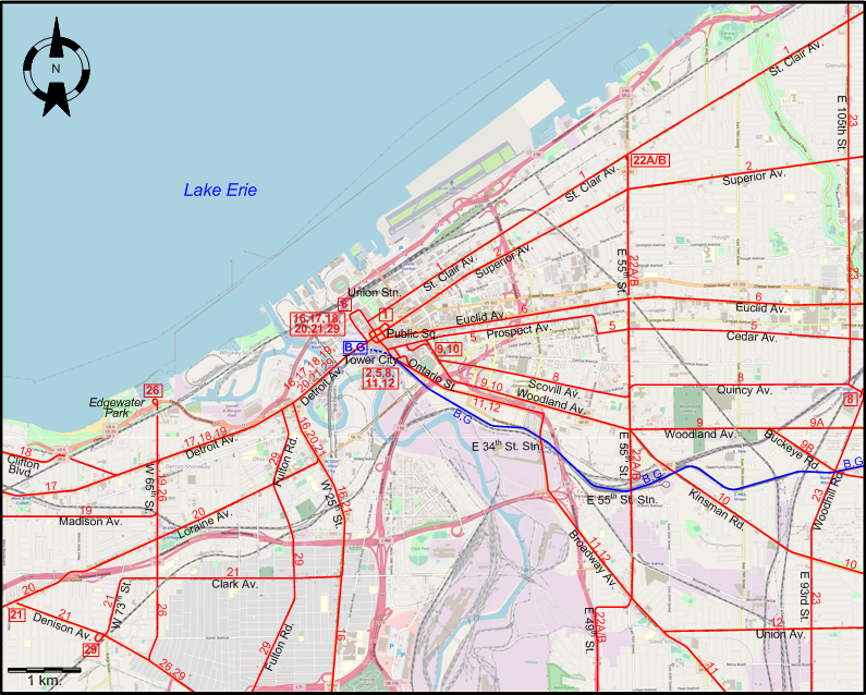
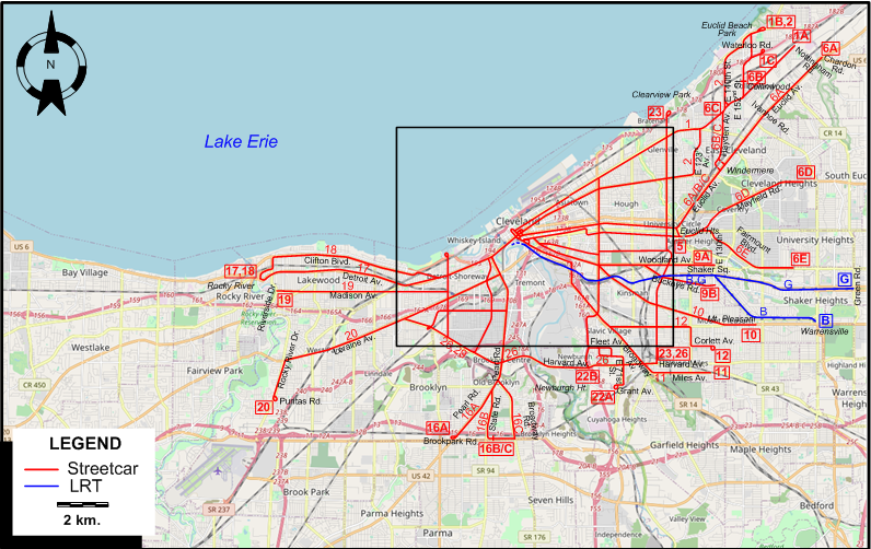
I created the above maps by overlaying OpenStreetMap (OSM) maps with my own data. Copyright on the OSM maps is © OpenStreetMap contributors, licensed under a CC-BY-SA (Creative Commons Attribution-ShareAlike 2.0 licence).
Please note that the OSM maps used as templates for these maps correspond to the situation at the time the maps were downloaded and may show features that did not exist at the time the GS Tram Site is supposed to show. In particular, they may show bridges and highways that were built later.
DISCONTINUATION DATES OF STREETCAR TRACKS BETWEEN 7 MAY 1946 AND 23 JAN. 1954 (affected route numbers in parentheses).
- 1946 May 7: Scovill Av. - Quincy Av. (8)
- 1946 June 16: Prospect Av. - Cedar Av. (5)
- 1947 Aug. 1: Pearl Rd. (between State Rd. & Brookpark Rd.) (16A)
- 1947 Aug. 16: Broadway (S of Union Blvd.) - Miles Av. (11)
- 1947 Sept. 3: Broadway (N of Union Av.) - E 116th St. - Corlett Av. (12)
- 1947 Nov. 16: Clifton Blvd. (18)
- 1948 Jan. 31: East 105th St. (23)
- 1948 March 7: W 65th St. (except between Detroit Av & Madison Av.)] (26); Denison Av. (E of Fulton Rd.) - Harvard Av. (to E 93rd St.) (26)
- 1948 March 10: Euclid Av. (between Ivanhoe Rd. & Chardon Rd.) (6A)
- 1948 March 15: Woodland Av. (E of Buckeye Rd.) (9A)
- 1948 Apr. 15: Euclid Av. (between Windermere & Ivanhoe Rd.) (6A)
- 1948 Apr. 30: Fulton Rd. - Denison Av. (to W 73rd St.) (29)
- 1948 July 1: Woodland Av. (between Kinsman Rd. & Buckeye Rd.) - Buckeye Rd. (9B)
- 1948 July 31: Fairmount Blvd. (6E)
- 1948 Aug. 1: Washington Blvd. (22B)
- 1949 Aug. 16: Hayden Av. (6B/C); E 152nd St. (6B)
- 1949 Sept. 7: Mayfield Rd (6D)
- 1950 March 26: Woodland Av. - Kinsman Rd. (10)
- 1950 June 18: Loraine Av. (W of 140th St.) - Rocky River Dr. - Puritas Rd. (20)
- 1950 July 2: Broadway Rd. (16C)
- 1951 Apr. 8: St. Clair Av. (E of 129th St.) - Nottingham Rd. (1A) / Euclid Beach Park (1B) / Waterloo Rd. (1C)
- 1951 Aug. 24: Detroit Av. (W of 65th St.)] (17)
- 1951 Nov. 3: St. Clair Av. (W of 129th St.) (1)
- 1952 Apr. 27: Euclid Av. (to Windermere) (6)
- 1952 June 14: Loraine Av. (between W 25th and 140th St.) (20)
- 1953 March 7: E 55th St. - E 49th St. (22A, earlier also 22B); Fleet Av. - E 71st St. (22A)
- 1953 March 20: Superior Av. - E 123rd Av. (2); E 140th St. - Euclid Beach Park (2)
- 1953 Aug. 15: W 25th St. (S to Clark Av.) (16B, 21); Clark Av. (21); W 25th St. - Pearl Rd. - State Rd. (16B)
- 1954 Jan. 23: Public Sq. - Detroit Av. - W 65th St. (between Detroit Av & Madison Av.]) - Madison Av. (19) [Last streetcar line in Cleveland]
ROUTES
CLEVELAND STREETCAR ROUTES
Operator: Cleveland Transit System
| 1 | St. Clair | Public Sq. - St. Clair Av. Eastward this route branches to: 1A (St. Clair Av. - Nottingham Rd.); 1B (St. Clair Av. - E 152nd St. - Euclid Beach Park); 1C (St. Clair Av. - E 152nd St. - Waterloo Rd.) |
| 2 | Superior | Ontario St. - Public Sq. - Superior Av. - E 123rd Av. - St. Clair Av. - E 140th St. - Euclid Beach Park |
| 5 | Cedar | Ontario St. - Prospect Av. - Cedar Av. - Euclid Hts. |
| 6 | Euclid | Union Stn. - Public Sq. - Euclid Av. Eastward this route branches to: 6A (Euclid Av. - Chardon Rd.); 6B (Euclid Av. - Hayden Av. - E 152nd St. - Collinwood); 6C (Euclid Av. - Hayden Av. - St. Clair Av.); 6D (Euclid Hts. - Mayfield Rd. - Cleveland Hts); 6E (Euclid Hts. - Fairmount Blvd. - University Hts) |
| 8 | Cedar | Ontario St. - Prospect Av. - Scovill Av. - Quincy Av. - Woodhill Rd. |
| 9A | Woodland | Prospect Av. - Woodland Av. - E 130th |
| 9B | Buckeye | Prospect Av. - Woodland Av. - Buckeye Rd. - E 130th |
| 10 | Kinsman | Prospect Av. - Woodland Av. - Kinsman Rd. - Mt. Pleasant |
| 11 | Broadway - Miles | Prospect Av. - Ontario St. - Broadway Av. - Miles Av. |
| 12 | Union | Prospect Av. - Ontario St. - Broadway Av. - Union Av. - E 116th St. - Corlett Av. |
| 16 | W 25th | Public Sq. - Detroit Av. - W 25th St. - Pearl Rd. Southward this route branches to: 16A (Pearl Rd. - Brookpark Rd.); 16B (State Rd. - W 35th St.); 16C (Broadway Rd. - Brookpark Rd.) |
| 17 | Detroit | Public Sq. - Detroit Av. - Rocky River |
| 18 | Clifton | Public Sq. - Detroit Av. - Clifton Blvd. - Rocky River |
| 19 | Madison | Public Sq. - Detroit Av. - W 65th St. - Madison Av. - Riverside Dr. |
| 20 | Lorain | Public Sq. - Detroit Av. - W 25th St. - Loraine Av. - Rocky River Dr. - Puritas Rd. |
| 21 | Clark Av. | Public Sq. - Detroit Av. - W 25th St. - Clark Av. - W 73rd St. - Denison Av. - Loraine Av. |
| 22A | E 55th - E 71st | St. Clair Av. - E 55th St. - E 49th St. - Fleet Av. - E 71st St. - Grant Av. |
| 22B | E 55th - Washington Blvd. | St. Clair Av. - E 55th St. - E 49th St. - E 49th St. - Washington Blvd. - Newburgh Ht. |
| 23 | East 105th St. | Clearview Park - E 105th St. - Woodhill Rd. - E 93rd St. - Harvard Av. |
| 26 | Harvard - Denison | Edgewater Park - W 65th St. - Denison Av. - Harvard Av. - E 93rd St. |
| 29 | Fulton - Denison W 73rd | Public Sq. - Detroit Av. - Fulton Rd. - Denison Av. - W 73rd St. |
LIGHT RAIL ROUTES
Operator: Shaker Heights Rapid Transit
| B | Blue Line | Tower City - E 34th St. Stn. - E 55th St. Stn. - Shaker Sq. - Shaker Hts. - Green Rd. |
| G | Green Line | Tower City - E 34th St. Stn. - E 55th St. Stn. - Shaker Sq. - Warrensville |
The streetcar route numbers and the letters used for light rail routes are of an indicative nature only, and were not used by the operator.
CHARACTERISTICS OF THE SYSTEM
NETWORK LENGTH
- Streetcar network: ? km.
- Light rail: ? km.
HISTORY
- Streetcars (traditional): (horse-powered) 5 Sept. 1860 - 1892; (steam): 1 Sept. 1868 - July 1882; (electric) 26 July 1894 - 23 Jan. 1954.
- Light rail: 17 Dec. 1913 - today.
- Cable cars: 17 Dec. 1890 - 15 Dec. 1901.
- Interurbans: 1895 - 15 May 1938.
GAUGE
- Streetcars & interurbans: 1435 mm.
SOURCES
- Canfield, J. (ed.) "Electric railways of Northeastern Ohio" Central Electric Railfans' Association Bulletin 1965 (#108).
- Simons, V. "Cleveland: 1980s confidence justified" Tramways & Urban Transit. July 2010 (73: 87), p.255-257.
WIKIS
- Blue Line (Cleveland)
- Cleveland Railway (Ohio)
- Greater Cleveland Regional Transit Authority
- Green Line (Cleveland)
- Lake Shore Electric Railway
- Red Line (Cleveland)
- RTA Light Rail Historic Route Maps
- RTA Rapid Transit
- Streetcars in Cleveland
- Waterfront Line
WEB SITES
Special thanks to Russell Powers from Denver CO for information on the history of the Cleveland system.
Copyright Gabor Sandi 1998-2026
Disclaimer: Everything on this site was written and/or prepared at the author's discretion. The author has tried to be accurate where facts are presented, but this does not mean that these facts are necessarily accurate. People needing more reliable information should refer to appropriate sources presented, on the Internet or elsewhere, by authoritative professional or academic bodies.
To get in touch with the webmaster, send an e-mail to g_sandi at hotmail.com.
Flags on this site are from the FOTW Flags Of The World website.