VIDEOS
 |
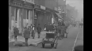 |
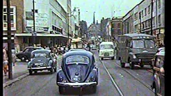
| Above: YouTubeCA video - Old Sheffield Tram Footage - STD The Changing scene - Length: 21:10 mins. | Above: YouTubeCA video - A short tram journey through the streets of Sheffield - Length: 8:59 mins. |
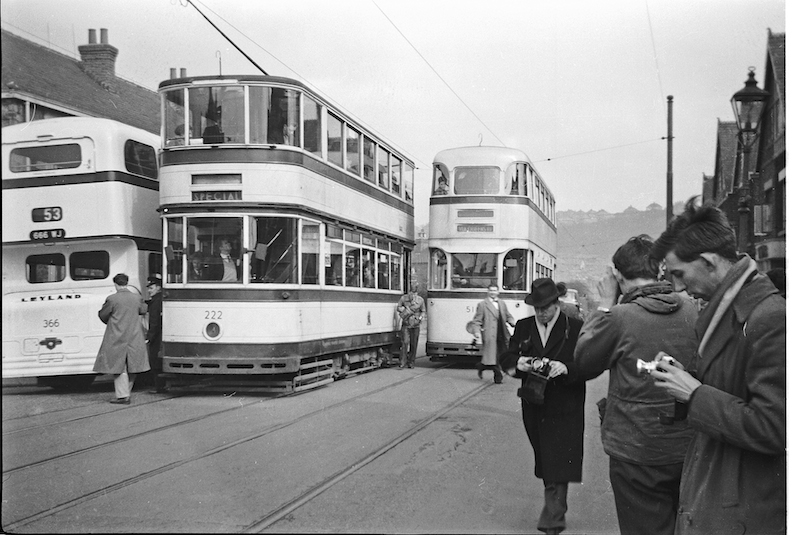
PHOTOS
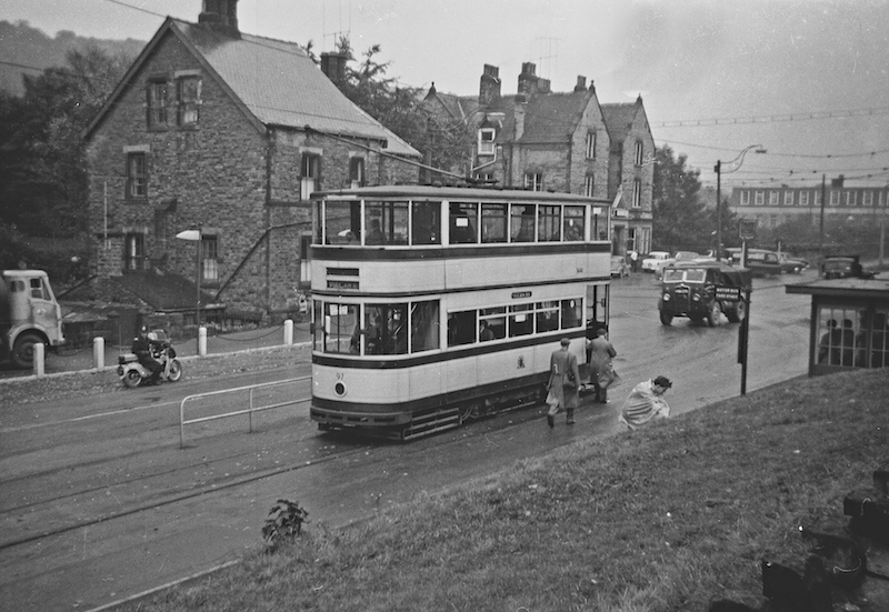 |
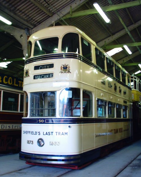 |
 |
MAPS
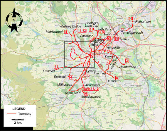
INSET: CENTRAL SHEFFIELD
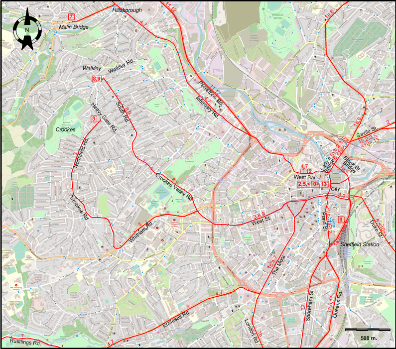
I created the above maps by overlaying OpenStreetMap (OSM) maps with my own data. The underlying map data is © OpenStreetMap contributors, licensed under the Open Database License (ODbL).
Please note that the OSM maps used as a template for these maps corresponds to the situation at the time the map was downloaded and may show features that did not exist at the time the GS Tram Site is supposed to show. In particular, it may show bridges and highways that were built later.
TRAM ROUTES
Operator: Sheffield Corporation Tramways
| 1a | Firth Park - Pitsmoor - Blonk St. Bridge - City - Sheffield Station - Queens Rd. - Heeley - Woodseats - Abbey Lane (continues as 1b) |
| 1b | Tinsley - Attercliffe - Savile St. - Lady’s Bridge - City - The Moor - London Rd. - Millhouses - Abbey Lane (continues as 1a) |
| 2 | City - Lady’s Bridge - Savile St. - Atlas - Brightside |
| 3 | Crookes (Heavy Gate Rd. at Northfield Rd.) - Northfield Rd. - Crookes Rd. - Whitham Rd. - West St. - City - Lady’s Bridge - Savile St. - Attercliffe - Darnall - Handsworth |
| 4 | Middlewood - Hillsborough - Infirmary Rd. - West Bar - City - The Moor - Ecclesall Rd. - Ecclesall |
| 5 | City - Lady’s Bridge - Savile St. - Attercliffe - Grimesthorpe - Pitsmoor - Firth Park |
| 6 | Sheffield Lane Top - Firth Park - Pitsmoor - Blonk St. Bridge - Sheffield Station - Queens Rd. - Heeley - Woodseats - Meadowhead |
| 7 | Malin Bridge - Hillsborough - Infirmary Rd. - West Bar - City - The Moor - Ecclesall Rd. - Rustlings Rd. - Fulwood |
| 8 | Walkley (Walkley Rd. at South Rd.) - Crookes Valley Rd. - South Rd. - West St. - City - Duke St. - Elm Tree - Intake |
| 9 | Walkley (Walkley Rd. at South Rd.) - Crookes Valley Rd. - South Rd. - West St. - City - Sheffield Station |
| 10 | City - Pond St. - Sheffield Station - Duke St. - Elm Tree - Prince of Wales Rd. - Darnall - Attercliffe - Savile St. - Lady’s Bridge - City [Circular route, both directions] |
| 11 | Wadsley Bridge - Penistone Rd. - West Bar - City - Pond St. - Queens Rd. - Heeley - Woodseats |
| 12 | Wadsley Bridge - Penistone Rd. - West Bar - City - Pond St. - Shoreham St. - Heeley - Woodseats |
| 13 | Rotherham - Templeborough - Tinsley - Attercliffe - Savile St. - Lady’s Bridge - City [Operated jointly with Rotherham Corporation] |
NB: Route numbers are indicative only, and were not used by the operator.
CHARACTERISTICS OF THE SYSTEM
NETWORK LENGTH
- Tramway: 77 km.
HISTORY
Tramways
- Horse–powered tramway: Oct. 1873 - Nov. 1902.
- First-generation electric tramway: 5 Sept. 1899 - 8 Oct. 1960.
- Revived tramway (electric overhead): 21 March 1994 – today.
- Tram-train (electric overhead): 25 Oct. 2018 - today.
GAUGE
- Tramway: 1435 mm.
SOURCES
- Bett, W.H. & Gillham, J.C. Great British tramway networks. London: Light Railway Transport League, 1962.
- Bower, R. "Sheffield Corporation Tramways", The Modern Tramway, June 1948 (11: 126), p.49; 52-54.
- Carroll, R. & Coulthard, S. "Learning from the past to improve the future: The UK Tram-train pilot five years on", Tramways & Urban Transit, Dec. 2023 (72: 864), p.471-474.
- Fox, P. "Tram operation in Sheffield: Progress, problems and a crisis". In: Light Rail Review 7. London: Light Rail Transit Association, 1995 [p.63-71].
- Jones, B. "Sheffield: South Yorkshire's quiet success story", Tramways & Urban Transit, June-July 2007 (70:834-835), p.212-216; 253-256.
- Pulling, N. "Systems Factfile No.40 - Sheffield Supertram, UK", Tramways & Urban Transit, Jan. 2011 (74:877), p.19-22.
- "The key is Supertram", Tramways & Urban Transit, Nov. 2024 (87: 1043), p.421-423.
- Read, G.. "Sheffield: Double the distance?", Tramways & Urban Transit, Aug. 2003 (66: 788), p.288-291.
WIKIS
- Rotherham Tramway
- Sheffield Supertram
- Sheffield Tramway
- South Yorkshire Passenger Transport Executive
- Stagecoach Group
- Transport in Sheffield
WEB SITES
Copyright Gabor Sandi 1998-2026
Disclaimer: Everything on this site was written and/or prepared at the author's discretion. The author has tried to be accurate where facts are presented, but this does not mean that these facts are necessarily accurate. People needing more reliable information should refer to appropriate sources presented, on the Internet or elsewhere, by authoritative professional or academic bodies.
To get in touch with the webmaster, send an e-mail to g_sandi at hotmail.com.
Flags on this site are from the FOTW Flags Of The World website.