VIDEOS
 |
 |
 |
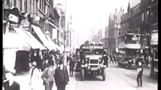
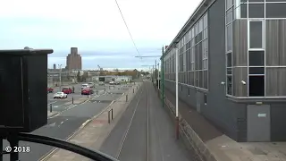
| Above: YouTubeCA video - Liverpool Trams - Green Goddesses Remembered - Length: 1:23:57 hrs. | Above: YouTubeCA video - Birkenhead Tram Ride October 2018 - Length: 7:25 mins. | Above: YouTubeCA video - Mersey Railway, 1940's - Film 17092 - Length: 1:49 mins. |
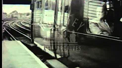 |
| Above: YouTubeCA video - Liverpool Overhead Railway, 1950's - Film 17093 - Length: 4:42 mins. |
PHOTOS
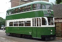
| 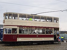
| 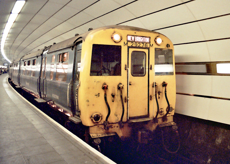
|
<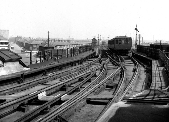 |
MAPS
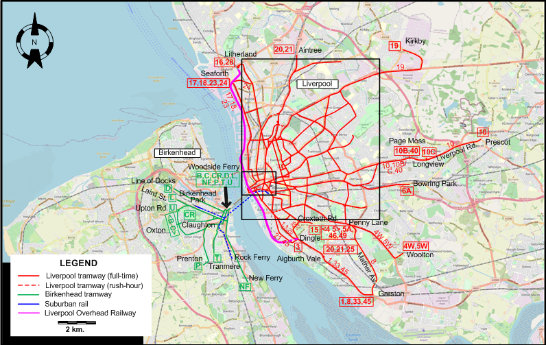
THE LIVERPOOL-BIRKENHEAD AREA
Note: The Liverpool and Birkenhead tram systems in the map below do not represent the networks at the same period of time. However, the Liverpool system in 1947 was very similar to what it had been in 1925.
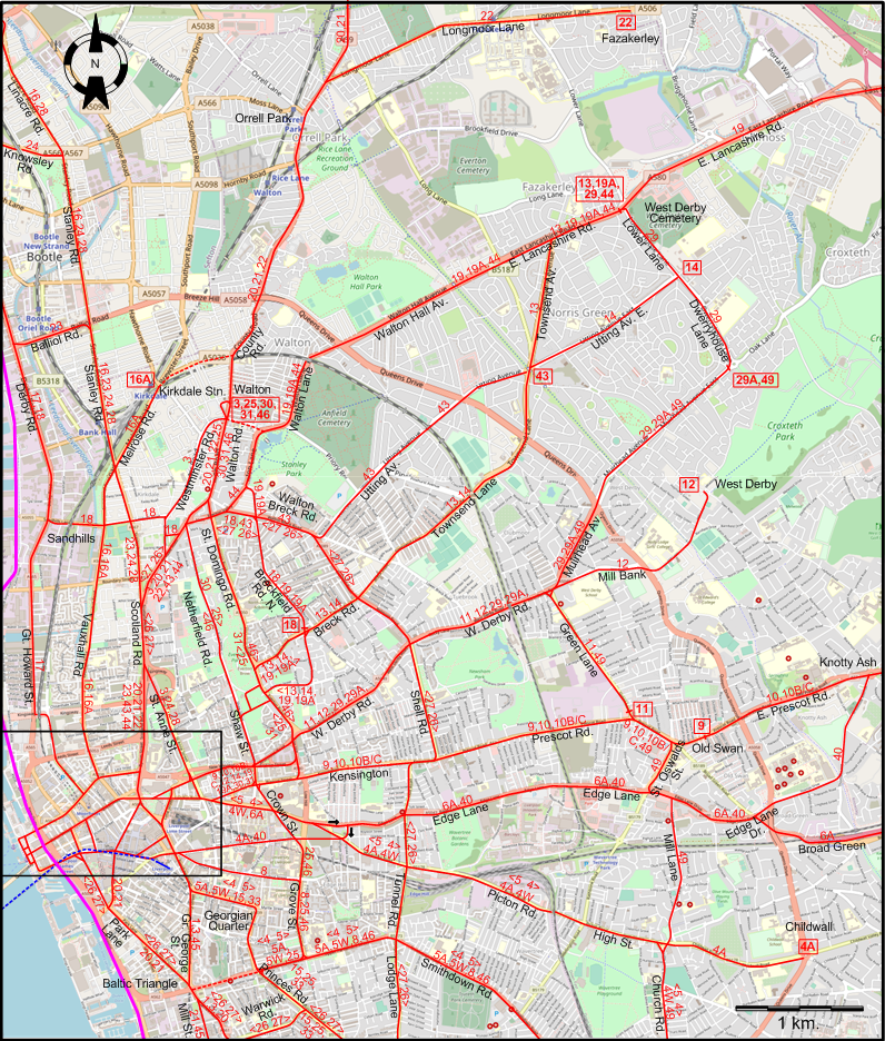
LIVERPOOL CENTRAL AREA
LIVERPOOL CORE
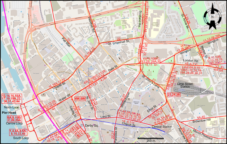
I created the above maps by overlaying OpenStreetMap (OSM) maps with my own data. The underlying map data is © OpenStreetMap contributors, licensed under the Open Database License (ODbL).
Please note that the OSM maps used as a template for these maps corresponds to the situation at the time the map was downloaded and may show features that did not exist at the time the GS Tram Site is supposed to show. In particular, it may show bridges and highways that were built later.
ROUTES
LIVERPOOL TRAM ROUTES
(As in 1947)
Operator: Liverpool Corporation Tramways
Note: Rush-hour routes are not shown.
| 1 | Pier Head (South Loop) - Lord St. - Church St. - Central Station - Renshaw St. - Gr. George St. - Baltic Triangle - Dingle - Aigburth Vale - Garston |
| 3 | Walton - Westminster Rd. - Scotland Rd. - St. Anne St. - Norton St. - London Rd. - Lime Street Station - Renshaw St. - Gr. George St. - Baltic Triangle - Dingle |
| 4 | Pier Head (South Loop) - Water St. - Dale St. - London Rd. - Picton Rd. - High St. - Church Rd. - Penny Lane - Smithdown Rd. - Georgian Quarter - Renshaw St. - Central Station - Church St. - Lord St. - Pier Head (South Loop) [Circular route, clockwise] |
| 4A | Pier Head (South Loop) - Lord St. - Church St. - Central Station - Brownlow Hill - Picton Rd. - High St. - Childwall |
| 4W | Castle St. - Dale St. - London Rd. - Picton Rd. - High St. - Church Rd. - Penny Lane - Woolton |
| 5 | Pier Head (South Loop) - Lord St. - Church St. - Central Station - Renshaw St. - Georgian Quarter - Smithdown Rd. - Penny Lane - Church Rd. - High St. - Picton Rd. - London Rd. - Dale St. - Water St. - Pier Head (South Loop) [Circular route, counter-clockwise] |
| 5A | Pier Head (South Loop) - Lord St. - Church St. - Central Station - Renshaw St. - Georgian Quarter - Smithdown Rd. - Penny Lane |
| 5W | Castle St. - Lord St. - Church St. - Central Station - Renshaw St. - Georgian Quarter - Smithdown Rd. - Penny Lane - Woolton |
| 6A | Pier Head (Centre Loop) - Lord St. - Church St. - Elliot St. - Lime Street Station - London Rd. - Edge Lane - Edge Lane Dr. - Broad Green - Bowring Park |
| 8 | Pier Head (South Loop) - Lord St. - Church St. - Central Station - Mount Pleasant - Grove St. - Smithdown Rd. - Penny Lane - Mather Av. - Garston |
| 9 | Pier Head (Centre Loop) - Water St. - Dale St. - London Rd. - Kensington - Prescot Rd. - Old Swan |
| 10 | Derby Sq. - Lord St. - Church St. - Elliot St. - Lime Street Station - London Rd. - Kensington - Prescot Rd. - Old Swan - E. Prescot Rd. - Knotty Ash - Page Moss - Liverpool Rd. - Prescot |
| 10B | Pier Head (Centre Loop) - Water St. - Dale St. - London Rd. - Kensington - Prescot Rd. - Old Swan - E. Prescot Rd. - Knotty Ash - Page Moss |
| 10C | Pier Head (Centre Loop) - Water St. - Dale St. - London Rd. - Kensington - Prescot Rd. - Old Swan - E. Prescot Rd. - Knotty Ash - Page Moss - Liverpool Rd. - Longview |
| 11 | N. John St. - [Lord St. - Church St. - Elliot St. - Lime Street Station - London Rd. - Norton St.] / [back: Islington - Dale St.] - Islington - W. Derby Rd. - Green Lane - Prescot Rd. |
| 12 | Derby Sq. - Lord St. - Church St. - Elliot St. - Lime Street Station - London Rd. - Prescot Rd. - W. Derby Rd. - Mill Bank - West Derby |
| 13 | Pier Head (North Loop) - Water St. - Dale St. - Islington - Shaw St. - Breck Rd. - Townsend Lane - Townsend Av. - E. Lancashire Rd. - West Derby Cemetery |
| 14 | Pier Head (North Loop) - Lord St. - Church St. - Elliot St. - Lime Street Station - London Rd. - Norton St. - Islington - Shaw St. - Breck Rd. - Townsend Lane - Utting Av. E. - Lower Lane |
| 15 | Pier Head (South Loop) - Lord St. - Church St. - Central Station - Renshaw St. - Georgian Quarter - Princes Rd. - Croxteth Rd. |
| 16 | Pier Head (North Loop) - Chapel St. - Vauxhall Rd. - Stanley Rd. - Linacre Rd. - Litherland |
| 16A | Pier Head (North Loop) - Chapel St. - Vauxhall Rd. - Melrose Rd. - Kirkdale Stn. |
| 17 | Pier Head (North Loop) - Chapel St. - Pall Mall - Gt. Howard St. - Derby Rd. - Seaforth |
| 18 | Breck Rd. - Breckfield Rd. N. - Sandhills - Derby Rd. - Seaforth |
| 19 | Pier Head (North Loop) - Lord St. - Church St. - Elliot St. - Lime Street Station - London Rd. - Norton St. - Islington - Shaw St. - Breckfield Rd. N. - Walton Lane - Walton Hall Av. - E. Lancashire Rd. - Kirkby |
| 19A | Pier Head (North Loop) - Lord St. - Church St. - Elliot St. - Lime Street Station - London Rd. - Norton St. - Islington - Shaw St. - Breckfield Rd. N. - Walton Lane - Walton Hall Av. - E. Lancashire Rd. - West Derby Cemetery |
| 20 | Aintree - Orrell Park - County Rd. - Walton - Walton Rd. - Scotland Rd. - Whitechapel - Paradise St. - Park Lane - Baltic Triangle - Dingle - Aigburth Vale |
| 21 | Aintree - Orrell Park - County Rd. - Walton - Walton Rd. - Scotland Rd. - Whitechapel - Paradise St. - Park Lane - Baltic Triangle - Mill St. - Dingle - Aigburth Vale |
| 22 | Pier Head (North Loop) - Chapel St. - Gt. Crosshall St. - Scotland Rd. - Walton Rd. - Walton - County Rd. - Orrell Park - Longmoor Lane - Fazakerley |
| 23 | Lime Street Station - St. John’s Lane - Scotland Rd. - Stanley Rd. - Balliol Rd. - Derby Rd. - Seaforth |
| 24 | Lime Street Station - London Rd. - Norton St. - St. Anne St. - Scotland Rd. - Stanley Rd. - Knowsley Rd. - Seaforth |
| 25 | Walton - Walton Rd. - [Netherfield Rd. - Shaw St.] [back: St. Domingo Rd.] - Crown St. - Grove St. - Princes Rd. - Dingle - Aigburth Vale |
| 26 | Derby Sq. - Castle St. - Dale St. - Scotland Rd. - Walton Breck Rd. - Shell Rd. - Kensington - Tunnel Rd. - Lodge Lane - Princes Rd. - Warwick Rd. - Park Lane - Derby St. ["Outer circular route", clockwise] |
| 27 | Derby Sq. - Park Lane - Warwick Rd. - Princes Rd. - Lodge Lane - Tunnel Rd. - Kensington - Shell Rd. - Walton Breck Rd. - Scotland Rd. - Dale St. - Castle Rd. - Derby Sq. ["Outer circular route", counterclockwise] |
| 28 | Lime Street Station - London Rd. - Norton St. - St. Anne St. - Scotland Rd. - Stanley Rd. - Linacre Rd. - Litherland |
| 29 | Pier Head (Centre Loop) - Water St. - Dale St. - Islington - W. Derby Rd. - Muirhead Av. - Dwerryhouse Lane - Lower Lane - West Derby Cemetery |
| 29A | Pier Head (Centre Loop) - Water St. - Dale St. - Islington - W. Derby Rd. - Muirhead Av. - Dwerryhouse Lane |
| 30 | Pier Head (North Loop) - Water St. - Dale St. - London Rd. - Shaw St. - Netherfield Rd. - Walton Rd. - Walton |
| 31 | Pier Head (North Loop) - Lord St. - Church St. - Elliot St. - Lime Street Station - London Rd. - St. Domingo Rd. - Walton Rd. - Walton |
| 33 | Pier Head (South Loop) - Lord St. - Church St. - Central Station - Renshaw St. - Georgian Quarter - Princes Rd. - Dingle - Aigburth Vale - Garston |
| 40 | Derby Sq. - Lord St. - Church St. - Central Station - Brownlow Hill - Edge Lane - Edge Lane Dr. - Knotty Ash |
| 43 | Pier Head (North Loop) - Water St. - Dale St. - Scotland Rd. - Walton Breck Rd. - Utting Av. - Townsend Av. |
| 44 | Pier Head (North Loop) - Water St. - Dale St. - Scotland Rd. - Walton Lane - Walton Hall Av. - E. Lancashire Rd. - West Derby Cemetery |
| 45 | Pier Head (South Loop) - Lord St. - Church St. - Central Station - Renshaw St. - Gr. George St. - Baltic Triangle - Mill St. - Dingle - Aigburth Vale - Garston |
| 46 | Walton - Walton Rd. - [St. Domingo Rd.] [back: Shaw St. - Netherfield Rd.] - Crown St. - Grove St. - Smithdown Rd. - Penny Lane |
| 49 | Dwerryhouse Lane - Muirhead Av. - Green Lane - Prescot Rd. - St. Oswalds St. - Mill Lane - Church Rd. - Penny Lane |
BIRKENHEAD TRAM ROUTES
(As on 30 Aug. 1925, last day of operation of route CR)
Operator: Birkenhead Corporation Tramways
| B | Woodside Ferry - Oxton [Circular route, clockwise] |
| C | Woodside Ferry - Oxton [Circular route, counter-clockwise] |
| CR | Woodside Ferry - Claughton |
| D | Woodside Ferry - Line of Docks |
| L | Woodside Ferry - Laird St. |
| NF | Woodside Ferry - New Ferry |
| P | Woodside Ferry - Prenton |
| T | Woodside Ferry - Tranmere |
| U | Woodside Ferry - Upton Rd. |
The route designation NF is for convenience only. It was not used by the operator.
SUBURBAN TRAIN ROUTES
(As in 1947)
Operator: London, Midland and Scottish Railway (LMS)
| Liverpool Central Station - Birkenhead Park | |
| Liverpool Central Station - Rock Ferry |
LIVERPOOL OVERHEAD RAILWAY (URBAN RAIL ROUTE)
(As in 1947)
Operator: Liverpool Overhead Railway Company
| Seaforth & Litherland - Pier Head - Dingle |
CHARACTERISTICS OF THE SYSTEM
NETWORK LENGTH
- Liverpool tramways: ca. 140 km.
- Suburban rail: 6 km.
- Liverpool Overhead Railway: 11 km.
HISTORY
Tramways
- Horse-powered tramways (Liverpool): (Experimental in 1859); 1 Nov. 1869 - 11 Dec. 1903 (?).
- Horse-powered tramways (Birkenhead): 30 Aug. 1860 [First permanent tramway in Europe] - 1901 (?)
- Electric tramways (Liverpool): 16 Nov. 1898 - 14 Sept. 1957.
- Electric tramways (Birkenhead): 4 Feb. 1901 - 17 July 1937.
- Suburban rail (Mersey Railway): (steam operated): 1 Feb. 1886 - 2 May 1903; (electric tranction): 2 May 1903 - today. (merged into the mainline rail system: 1948)
- Liverpool Overhead Railway (electric): 6 March 1893 - 30 Dec. 1956.
GAUGE
- Liverpool tramways: 1435 mm.
- Birkenhead tramways: 1435 mm.
- Suburban rail (Mersey Railway): 1435 mm.
- Liverpool Overhead Railway: 1435 mm.
TRAM PRESERVATION
The Wirral Transport Museum, in Birkenhead, has a collection of vintage trams from various systems in the Liverpool-Birkenhead area. It also has a 1.1 km. long heritage tram line, on which the museum trams can be operated.
SOURCES
- Barklay, J. "Merseyside: Why we need a tram", Tramways & Urban Transit, Oct. 2008 (71: 850), 380-381.
- Bett, W.H. & Gillham, J.C. Great British tramway networks. London: Light Railway Transport League, 1962.
- Forbes, N.N. "Birkenhead Tramways", The Modern Tramway, Feb. 1946 (9: 98), p.9, 14-16; Oct. 1943 (6: 70), p.77, 84.
- Gillham, J.C. & Wiseman, R.J.S. The tramways of South Lancashire abd North Wales. Broxbourne, Hertsh.: Light Rail Transit Association, 2003.
- Maund, T.B. & Hardy, P.L. "History of the Liverpool Corporation Tramways", The Modern Tramway, Sept. 1943 (6: 69), p.69, 74-76; Oct. 1943 (6: 70), p.77, 84.
- McNaught, R.S. "The tram in Birkenhead", Modern Tramway, May 1972 (35: 413), p.163-170, 183.
- "Tramway services at Liverpool, 1939", The Modern Tramway, Feb. 1943 (6: 62), p.18.
WIKIS
- Birkenhead Corporation Tramways
- Liverpool Corporation Tramways
- Liverpool Overhead Railway
- Liverpool Tramways Company
- Mersey Railway
- Merseyrail
- Merseytram
WEB SITES
- Liverpool Overhead Railway
- Merseyrail
- Munro, S.A. Tramway companies in Liverpool, 1859-1897
- Thomas Parker - The Liverpool Overhead Railway
Thanks to Urs Mattmann (from London, England) for information he kindly sent me concerning the Liverpool Overhead Railway.
Copyright Gabor Sandi 1998-2026
Disclaimer: Everything on this site was written and/or prepared at the author's discretion. The author has tried to be accurate where facts are presented, but this does not mean that these facts are necessarily accurate. People needing more reliable information should refer to appropriate sources presented, on the Internet or elsewhere, by authoritative professional or academic bodies.
To get in touch with the webmaster, send an e-mail to g_sandi at hotmail.com.
Flags on this site are from the FOTW Flags Of The World website.