VIDEOS
 |
 |
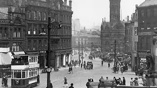
| Above: YouTubeCA video - A voice from Bradfords past (incl. trams) - Length: 8:45 mins. | Above: YouTubeCA video - The History Programme | Huddersfield Tram Fleet - Length: 12:57 mins. |
PHOTO
 |
MAPS
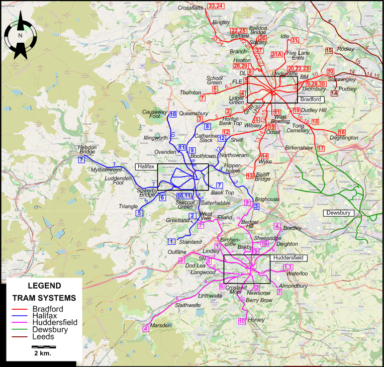
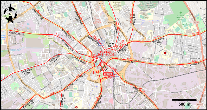
INSET: CENTRAL BRADFORD
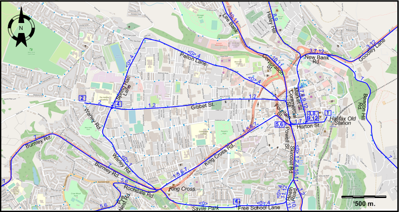
INSET: CENTRAL HALIFAX
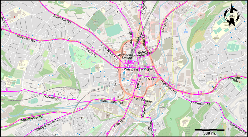
INSET: CENTRAL HUDDERSFIELD
ABBREVIATIONS ON THE MAPS
| BM | Bradford Moor | LHL | Little Horton Lane |
| DL | Duckworth Lane | NS | Norfolk Street |
| FLE | Four Lane Ends | SN | Salendine Nook |
| GHR | Great Horton Road | TH | Town Hall Street |
| HI | Hall Ings | TS | Tyrrel Street |
I created the above maps by overlaying OpenStreetMap (OSM) maps with my own data. Copyright on the OSM maps is © OpenStreetMap contributors, licensed under a CC-BY-SA (Creative Commons Attribution-ShareAlike 2.0 licence).
Please note that the OSM maps used as templates for these maps correspond to the situation at the time the maps were downloaded and may show features that did not exist at the time the GS Tram Site is supposed to show. In particular, they may show bridges and highways that were built later.
ROUTES
BRADFORD TRAM ROUTES
Operator: Bradford Corporation Tramways
| 1 | Tyrrel St. - Morley St. - Easby Rd. - Laisteridge Lane - Little Horton Lane - Wibsey |
| 2 | Tyrrel St. - Morley St. - Easby Rd. - Great Horton Rd. - Horton Bank Top |
| 3 | Tyrrel St. - Morley St. - Easby Rd. - Great Horton Rd. - Horton Bank Top - Queensbury |
| 4 | Tyrrel St. - Thornton Rd. - Listerhills Rd. - Legrams Lane - Lidget Green |
| 5 | Sunbridge Rd. - Thornton Rd. - Four Lane Ends |
| 6 | Sunbridge Rd. - Thornton Rd. - Four Lane Ends - School Green |
| 7 | Sunbridge Rd. - Thornton Rd. - Four Lane Ends - School Green - Thornton |
| 8 | Sunbridge Rd. - Westgate - Whetley Hill - Duckworth Lane |
| 9 | Hall Ings - Leeds Rd. - Thornbury |
| 10 | Hall Ings - Leeds Rd. - Thornbury - Stanningley |
| 11 | Town Hall St. - Manchester Rd. - West Bowling |
| 12 | Town Hall St. - Manchester Rd. - Odsal - Shelf |
| 13 | Town Hall St. - Manchester Rd. - Odsal - Wyke - Bailiff Bridge |
| 14 | Town Hall St. - Manchester Rd. - Odsal - Wyke |
| 15 | Town Hall St. - Manchester Rd. - Odsal |
| 16 | Norfolk St. - Wakefield Rd. - Dudley Hill - Drighlington - Tong - Drighlington |
| 17 | Norfolk St. - Wakefield Rd. - Dudley Hill - Drighlington - Tong - Birkenshaw |
| 18 | Norfolk St. - Wakefield Rd. - Dudley Hill - Drighlington - Tong Cemetery |
| 19 | Norfolk St. - Wakefield Rd. - Dudley Hill |
| 20 | Undercliffe - Otley Rd. - Barkerend Rd. - Forster Sq. |
| 22 | Undercliffe - Otley Rd. - Barkerend Rd. - Forster Sq. - Manor Row - Manningham Lane - Branch - Saltaire |
| 23 | Undercliffe - Otley Rd. - Barkerend Rd. - Forster Sq. - Manor Row - Manningham Lane - Branch - Saltaire - Bingley - Crossflatts |
| 24 | Forster Sq. - Manor Row - Manningham Lane - Branch - Saltaire - Bingley - Crossflatts |
| 25 | Forster Sq. - Manor Row - Manningham Lane - Branch - Saltaire |
| 26 | Forster Sq. - Manor Row - Manningham Lane - Branch - Shipley - Baildon Bridge |
| 27 | Forster Sq. - Manor Row - Manningham Lane - Branch |
| 28 | Forster Sq. - Manor Row - Manningham Lane - Heaton |
| 29 | Bradford Moor - Barkerend Rd. - Forster Sq. - Manor Row - Manningham Lane - Heaton |
| 30 | Bradford Moor - Barkerend Rd. - Forster Sq. |
| 31 | Forster Sq. - Bolton Rd. - Five Lane Ends - Idle |
| 31A | Forster Sq. - Bolton Rd. - Five Lane Ends |
HALIFAX TRAM ROUTES
Operator: Halifax Corporation Tramways
| 0 | Commercial St. - Pellon Lane - Spring Hall Lane - Warley Rd. - King Cross - Free School Lane - Heath Road - Skircoat Rd. - Commercial St. [Circular Route, both directions] |
| 1 | Halifax Old Station - Horton St. - Commercial St. - Gibbet St. - Spring Hall Lane - Warley Rd. - King Cross - King Cross Rd. - Fountain St. - Skircoat Rd. - Salterhebble - Greetland - Stainland |
| 2 | Warley Rd. - Gibbet St. - Commercial St. - Skircoat Rd. - Salterhebble - Greetland |
| 3 | Horton St. - Market St. - New Bank Rd. - Goodley Lane - Hipperholme - Brighouse |
| 4 | Savile Park - Free School Lane - Heath Road - Skircoat Rd. - Commercial St. - Pellon Lane - Spring Hall Lane - Gibbet St. |
| 5 | Powell St. - Fountain St. - King Cross Rd. - King Cross - Rochdale Rd. - Pye Nest Rd. - Sowerby Bridge - Triangle |
| 6 | Powell St. - Fountain St. - King Cross Rd. - King Cross - Rochdale Rd. - Pye Nest Rd. - Sowerby Bridge - Triangle |
| 7 | Hebdon Bridge - Mytholmroyd - Luddenden Foot - Burnley Rd. - King Cross - King Cross Rd. - Fountain St. - Horton St. - Market St. - New Bank Rd. - Beacon Hill Rd. - Bank Top |
| 8 | Horton St. - Market St. - Haley Hill - Boothtown - Catherine Slack - Queensbury |
| 9 | Horton St. - Market St. - Haley Hill - Boothtown |
| 10 | Skircoat Green - Heath Road - Skircoat Rd. - Commercial St. - Corporation St. - Lee Bank - Ovenden - Illingworth - Causeway Foot |
| 11 | Skircoat Green - Heath Road - Skircoat Rd. - Commercial St. - Corporation St. - Lee Bank - Ovenden |
| 12 | Horton St. - Market St. - New Bank Rd. - Goodley Lane - Northowram - Shelf |
HUDDERSFIELD TRAM ROUTES
Operator: Huddersfield Corporation Tramways
| 1 | Lindley - Acre St. - New Hay Rd. - Trinity St. - Huddersfield Station - Westgate - King St. [back: Kirkgate] - Wakefield Rd. - Waterloo |
| 2 | Huddersfield Station - New St. - East Parade - Queen St. - Newsome Rd. - Newsome |
| 3 | Outlane - Salendine Nook - New Hay Rd. - Trinity St. - Huddersfield Station - Westgate - King St. [back: Kirkgate] - Wakefield Rd. - Waterloo |
| 4 | Bradley - Deighton - Leeds Rd. - Northumberland St. - New St. - Manchester Rd. - Linthwaite - Slaithwaite - Marsden |
| 6 | Huddersfield Station - New St. - Manchester Rd. - Blackmoorfoot Rd. - Crosland Moor |
| 7 | West Vale - Elland - Birchencliffe - Edgerton Rd. - New North Rd. - King St. [back: Kirkgate] - Wakefield Rd. - Somerset Rd. - Almondbury |
| 8 | Birkby - St. John’d Rd. - New St. - Manchester Rd. - Longwood - Dod Lea |
| 9 | Huddersfield Station - [Northumberland St. - Northgate] [back: Viaduct St.] - Bradford Rd. - Birkby - Badger Hill - Brighouse |
| 10 | Honley - Berry Brow - Folly Hall - New St. - [Northumberland St. - Northgate] [back: Viaduct St.] - Bradford Rd. - Birkby - Sheepridge |
LEEDS TRAM ROUTES
Operator: Leeds Corporation Tramways
| 4 | City Centre - Wellington St. - Kirkstall Rd. - Abbey Rd. - New Road Side - Rawdon Rd. - Leeds Rd. - Guiseley |
| 14 | Corn Exchange - City Centre - Wellington St. - Wellington Rd. - Armley Rd. - Stanningley Rd. - Bramley - Stanningley - Pudsey |
| 15 | Corn Exchange - City Centre - Wellington St. - Wellington Rd. - Armley Rd. - Stanningley Rd. - Upper Town St. - Rodley |
DEWSBURY TRAM ROUTES
Operator: Yorkshire (Woollen District) Electric Tramways Ltd.
No formal route numbers
CHARACTERISTICS OF THE SYSTEM
NETWORK LENGTH
- Bradford Corporation Tramways: 94.3 km. (max. extent)
- Halifax Corporation Tramways: 62.9 km. (max. extent)
- Huddersfield Corporation Tramways: 63.0 km. max. extent)
- Yorkshire (Woollen District) Electric Tramways Ltd.: 36.4 km.
HISTORY
Tramways
- Bradford tramways (horse-traction): 2 Feb. 1882 - 31 Jan. 1902; (steam-traction): 3 Aug. 1882 - 5 June 1902; (electric): 30 July 1898 - 6 May 1950.
- Halifax tramways (electric): 29 June 1898 - 14 Feb. 1939.
- Huddersfield tramways (horse-traction): 9 May 1885 - 1 Apr. 1888; (steam-traction): 11 Jan. 1883 - 21 June 1992; (electric): 14 Feb. 1901 - 29 June 1940.
- Dewsbury tramways (electric): 18 Feb. 1903 - 31 Oct. 1934.
- Leeds tramways (horse traction): 16 Sept. 1871 - 13 Oct. 1901; (steam traction): 17 June 1880 - 1 Apr. 1902.; (electric): 11 Nov. 1891 - 7 Nov. 1959.
GAUGE
- Tramways (Bradford): 1219 mm.
- Tramways (Halifax): 1067 mm.
- Tramways (Huddersfield): 1416 mm.
- Tramways (Dewsbury): 1435 mm.
- Tramways (Leeds): 1435 mm.
SOURCES
- Gillham, J.C. & Wiseman R.J.S. The tramways of West Yorkshire. Broxbourne: Light Transit Association, 2001.
- King, J.S. "Bradford to Leeds", Modern Tramway and Light Rail Review, June 1969 (32: 378), p.192-201.
- Price, J.H. & King, J.S. "The Bradford tramcar", The Modern Tramway, June 1961 (24: 282), p.156-162.
WIKIS
- Bradford Corporation Tramways
- Halifax Corporation Tramways
- Huddersfield Corporation Tramways
- Yorkshire (West Riding) Electric Tramways
WEB SITES
Copyright Gabor Sandi 1998-2026
Disclaimer: Everything on this site was written and/or prepared at the author's discretion. The author has tried to be accurate where facts are presented, but this does not mean that these facts are necessarily accurate. People needing more reliable information should refer to appropriate sources presented, on the Internet or elsewhere, by authoritative professional or academic bodies.
To get in touch with the webmaster, send an e-mail to g_sandi at hotmail.com.
Flags on this site are from the FOTW Flags Of The World website.