VIDEOS
 |
 |
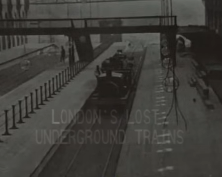 |
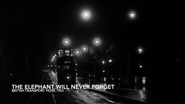
| Above: YouTubeCA video - London trams 1952 - Length: 10:53 mb_regex_set_options. | Above: YouTubeCA video - The Last Days of the Old London Trams - Length: 6:48 mins. | Above: YouTubeCA video - London Underground - Lost Trains - Archive footage - London Transport History - Length: 55:11 mins. |
PHOTOS
 |
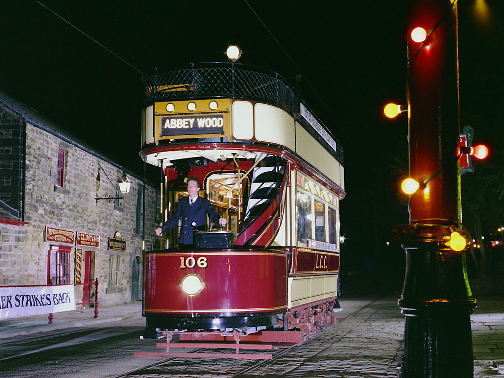 |
 |
MAPS
Because of the complexity of the London-area rail transportation system, there are altogether six maps showing the routes:
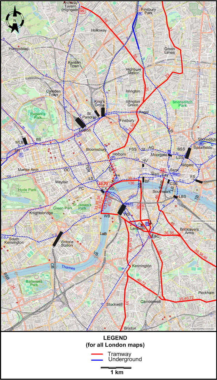
- A map showing Central London
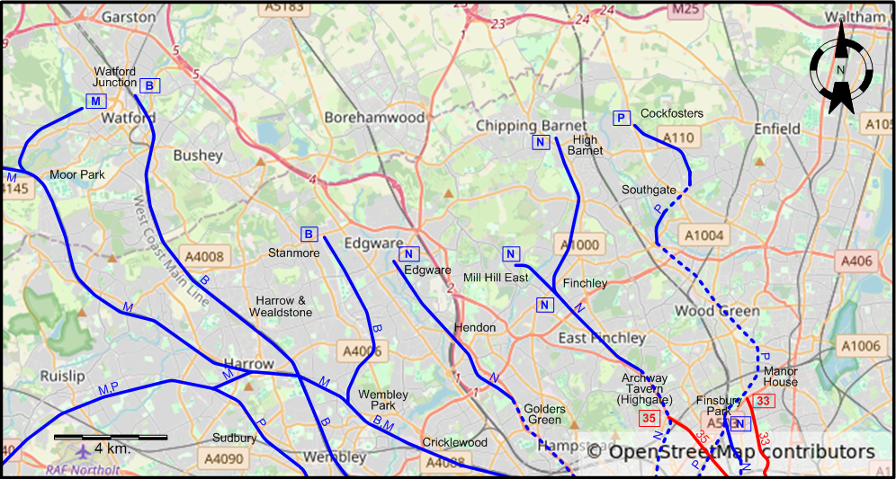
- A map showing North London
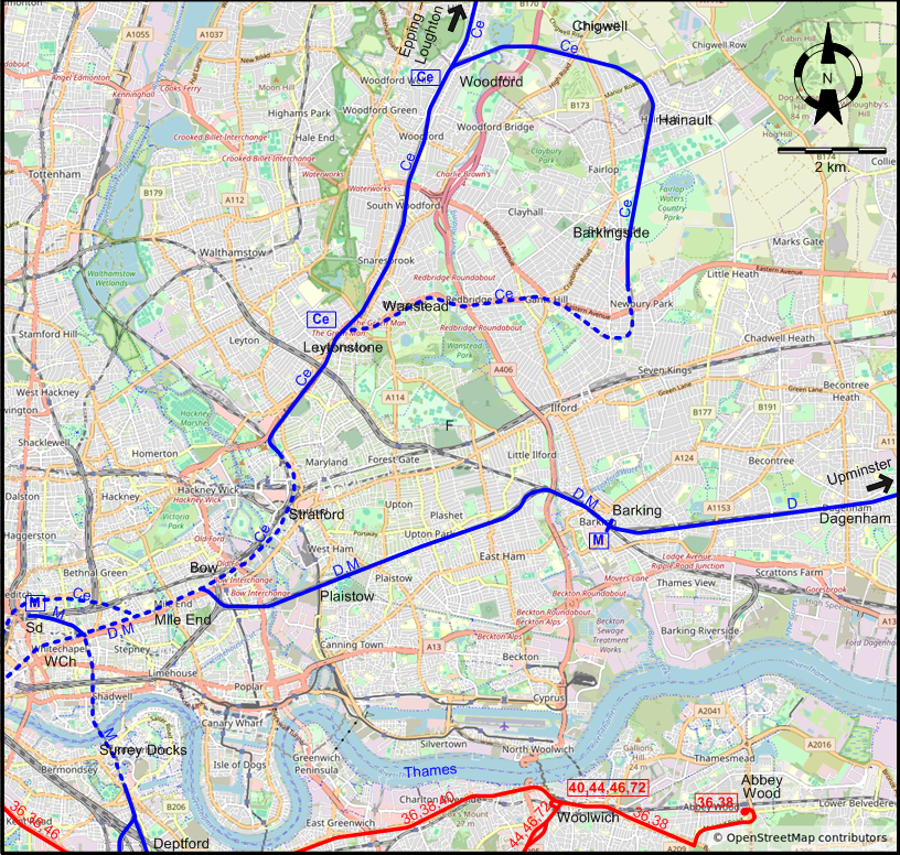
- A map showing East London
- A map showing Southeast London
- A map showing South London
- A map showing West London
It is possible to by-pass the maps:
CENTRAL LONDON
NORTH LONDON
EAST LONDON
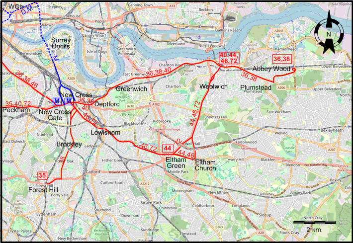
SOUTHEAST LONDON
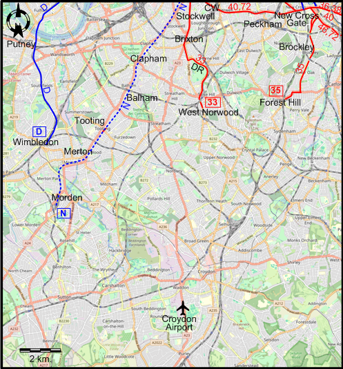
SOUTH LONDON
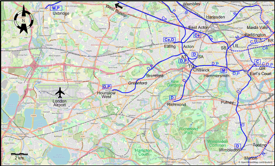
WEST LONDON
ABBREVIATIONS ON THE MAPS
| AG | Aldersgate | LR | Latimer Road |
| AT | Acton Town | LS | Leicester Square |
| Aw | Aldwych | LSS | Liverpool Street Station |
| BB | Blackfriars Bridge | MaH | Mansion House |
| BF | Blackfriars | MLB | Marylebone |
| BS | Baker Street | OC | Oxford Circus |
| BSB | Battersea Bridge | OS | Old Street |
| BSS | Broad Street Station | PC | Piccadilly Circus |
| CB | Chelsea Bridge | SA | South Acton |
| CSS | Cannon Street Station | SB | Shepherd's Bush |
| CW | Camberwell | Sd | Shoreditch |
| CX | Charing Cross | Sf | Smithfield |
| DR | Dulwich Road | SS | Savoy Street |
| E&C | Elephant & Castle | SWB | Southwark Bridge |
| ER | Edgware Road | TB | Tower Bridge |
| FS | Fenchurch Street Station | TCR | Tottenham Court Road |
| FSS | Farringdon Street Station | TG | Turnham Green |
| GR | Gloucester Road | VB | Vauxhall Bridge |
| HV | Holborn Viaduct Station | VE | Victoria Embankment |
| KS | Kingsway Subway | WB | Westminster Bridge |
| LaB | Lambeth Bridge | WCh | Whitechapel |
| LB | London Bridge | WS | Waterloo Station |
| LBS | London Bridge Station |
I created the above maps by overlaying OpenStreetMap (OSM) maps with my own data. The underlying map data is © OpenStreetMap contributors, licensed under the Open Database License (ODbL).
Please note that the OSM maps used as a template for these maps corresponds to the situation at the time the map was downloaded and may show features that did not exist at the time the GS Tram Site is supposed to show. In particular, it may show bridges and highways that were built later.
ROUTES
Operator: London Transport Executive
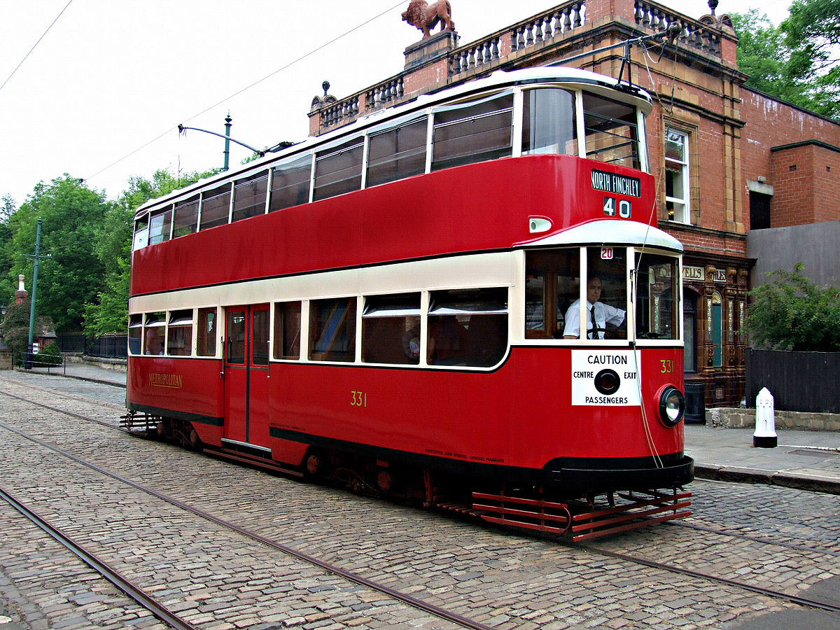
TRAM ROUTES
| 33 | Manor House – Green Lanes – Islington – Angel – Bloomsbury – Kingsway Subway – Victoria Embankment – Westminster Bridge – Kennington – Brixton – Dulwich Road – West Norwood |
| 35 | Highgate (Archway Tavern) – Holloway – Islington – Angel – Bloomsbury – Kingsway Subway – Victoria Embankment – Westminster Bridge – Elephant & Castle – Camberwell – Peckham – New Cross – Brockley – Forest Hill |
| 36 | Victoria Embankment – Westminster Bridge [back: Blackfriars Bridge ] – Elephant & Castle – Bricklayers Arms – New Cross – Greenwich – Woolwich – Plumstead – Abbey Wood |
| 38 | Victoria Embankment – Blackfriars Bridge [back: Westminster Bridge] – Elephant & Castle – Bricklayers Arms – New Cross – Greenwich – Woolwich – Plumstead – Abbey Wood |
| 40 | Victoria Embankment (Savoy Street) – Westminster Bridge – Kennington – Camberwell – Peckham – New Cross – Greenwich – Woolwich |
| 44 | Woolwich – Eltham Church – Eltham Green [Weekdays only] |
| 46 | City – Southwark Bridge – Southwark – New Cross – Lewisham – Eltham Green – Eltham Church – Woolwich |
| 72 | Victoria Embankment (Savoy Street) – Westminster Bridge – Kennington – Camberwell – Peckham – New Cross – Lewisham – Eltham Green – Woolwich |
UNDERGROUND ROUTES
Note: The one- or two-letter route designations are strictly local to this site, and have never been used by the operating companies. Branches of individual lines are listed separately.
| B | Bakerloo Line | Elephant & Castle – Waterloo – Charing Cross – Piccadilly Circus – Oxford Circus – Marylebone – Paddington – Maida Vale – Harlesden – Wembley – Harrow & Wealdstone – Watford Junction |
| B | Bakerloo Line | [Branch:] Baker Street – South Hampstead – Wembley Park – Stanmore |
| C | Circle Line | Gloucester Road – South Kensington – Victoria Station – Embankment – Blackfriars – Aldgate – Liverpool Street Station - Farringdon Street Station – King's Cross St Pancras – Euston – Baker Street – Edgware – Paddington – Notting Hill – High Street Kensington – Gloucester Road [Circular route, both directions] |
| Ce | Central Line | Epping – Loughton – Woodford – Leytonstone – Leyton – Stratford – Mile End – Liverpool Street Station – Bank – Holborn – Tottenham Court Road – Oxford Circus – Marble Arch – Notting Hill – Shepherd's Bush – East Acton – Ealing Broadway |
| Ce | Central Line | [Branch]: Ongar – Epping [Steam traction] |
| Ce | Central Line | [Branch]: Woodford – Chigwell – Hainault – Barkingside – Wanstead – Leytonstone |
| Ce | Central Line | North Acton – Greenford – West Ruislip |
| D | District Line | [Ealing Broadway – Acton Town] / [Richmond] – Turnham Green – Hammersmith – Earl's Court – Gloucester Road – South Kensington – Victoria Station – Embankment – Blackfriars – Aldgate – Whitechapel – Mile End – Barking – Dagenham – Upminster |
| D | District Line | [Branch:] Edgware Road – Paddington Station – Notting Hill – High Street Kensington – Earl's Court – Putney – Wimbledon |
| D | District Line | [Branch:] Hounslow West – Acton Town |
| D | District Line | [Branch:] Acton Town – South Acton |
| D | District Line | [Branch:] Earl's Court – Kensington (Olympia) |
| M | Metropolitan Line | Hammersmith – Shepherd's Bush – Paddington – Edgware – Baker Street – Euston – King's Cross St Pancras – Farringdon Street Station – Moorgate – Liverpool Street Station – Aldgate – Whitechapel – Mile End – Barking |
| M | Metropolitan Line | [Branch:] Baker Street – South Hampstead – Wembley Park – Harrow – Ruislip – Uxbridge |
| M | Metropolitan Line | [Branch:] Harrow – Moor Park – Watford / Chesham / Brill / Verney Junction |
| M | Metropolitan Line | [Branch:] Shoreditch – Whitechapel – Surrey Docks – New Cross Gate / New Cross |
| N | Northern Line | Edgware – Hendon – Golders Green – Hamstead – Camden Town – Euston – Tottenham Court Road – Leicester Square – Charing Cross – Waterloo – Kennington – Stockwell – Clapham – Tooting – Morden |
| N | Northern Line | [Branch:] High Barnet – Finchley – Highgate – Archway – Kentish Town – Camden Town |
| N | Northern Line | [Branch:] Camden Town – Euston – King's Cross St.Pancras – Angel – Old Street – Moorgate – Bank – Elephant & Castle – Kennington |
| N | Northern Line | [Branch:] Moorgate – Finsbury Park |
| N | Northern Line | [Branch:] Finchley – Mill Hill East |
| P | Piccadilly Line | Uxbridge – Ruislip – Sudbury – North Ealing – Acton Town – Turnham Green – Hammersmith – Earl's Court – Gloucester Road – South Kensington – Knightsbridge – Piccadilly Circus – Leicester Square – Holborn – King's Cross St.Pancras – Finsbury Park – Manor House – Wood Green – Southgate – Cockfosters |
| P | Piccadilly Line | [Branch:] Hounslow West – Acton Town |
| P | Piccadilly Line | [Branch]: Holborn – Aldwych |
| W&C | Waterloo & City Line | Waterloo – Bank |
CHARACTERISTICS OF THE SYSTEM
NETWORK LENGTH
- Tramway: 164 km.
- Underground: ? km.
HISTORY
Tramways
- Horse–powered:1860 – (First World War.)
- First-generation electric tramway (conduit and overhead electric supply): 1901 - 6 July 1952.
- Revived tramway (electric overhead): May 2000 – today.
Rapid transit
- Dockland Light Railway (electric, 3rd rail): 31 Aug. 1987 - today.
- Underground: 10 Jan. 1863 - today (steam: 1863 - 1961; electric: 18 Dec. 1890 - today)
- Regional express (Elizabeth Line): 24 May 2022 - today.
GAUGE
- Tramway (1st generation): 1435 mm.
- Dockland Light Railway: 1435 mm.
- Underground: 1435 mm. (also 2140 mm., 1863-1869)
- Regional express (Elizabeth Line): 1435 mm.
SOURCES
- Bett, W.H. & Gillham, J.C. Great British tramway networks. London: Light Railway Transport League, 1962.
- British Railways pre-grouping Atlas and Gazetteer. London: Ian Allan, 5th ed., 1980.
- Johnston, H."London’s DLR - New trains soon: Who will operate them?", Tramways & Urban Transit, Nov. 2023 (86: 1031), p.416-420.
- Johnston, H."Piccadilly Line - New trains coming", Tramways & Urban Transit, Apr. 2024 (87: 1036), p.128-129.
- "London Tramlink", Tramways & Urban Transit, May 2012 (75: 893), Supplement, 16p.
- "London Underground: 150 years and moving forward", Tramways & Urban Transit, Feb. 2014 (77: 914), p.61-79.
- Oakley, E.R. & Holland, C.E. London Transport Tramways, 1933-1952. Bexleyheath (Kent): London Tramways History Group, 1998.
- Owen, N. "Croydon: A successful first half-year", Tramways & Urban Transit, Dec. 2000 (63: 756), p.448-450.
- Pulling, N. "System Factfile No. 34: London Docklands, UK", Tramways & Urban Transit, July 2010 (73: 871), p.259-262.
- Pulling, N. "System Factfile No. 141: London trams, UK", Tramways & Urban Transit, July 2019 (82: 979), p.263-267.
- Pulling, N. "System Factfile No. 224: London Docklands Light Railway, UK", Tramways & Urban Transit, June 2026 (89: 1062), p.226-231.
- Rose, D. The London Underground: A diagrammatic history (sheet map). London: Douglas Rose, 2nd ed., 1983.
- The spread of London's Underground. London: Capital Transport, 4th ed., 2024.
- Streeter; T. "DLR: BIM Innovations", Tramways & Urban Transit, March 2016 (79: 939), p.100-102.
- Trolleybus & tram route map (sheet map). London: London Transport, 1950.
- Wyse, J. & Bayman, B. "Light rail comes to London: The DLR opens". In: Light Rail '87. London: Light Rail Transit Association, 1987 [p.13-24].
WIKIS
- Docklands Light Railway
- Elizabeth line
- History of public transport authorities in London
- History of the London Underground
- Kingsway tramway subway
- London Passenger Transport Board
- London Underground
- Railway electrification in Great Britain
- Tramlink
- Trams in London
- Transport for London
- Tube map
WEB SITES
- The campaign to save the London Trams, 1946-1952
- London (on UrbanRail.Net)
- MTR Elizabeth line
- Trams in London
- Transport for London
Also, thanks to Geoffrey Tribe (from Leighton Buzzard, England) for information obtained through personal communication.
Copyright Gabor Sandi 1998-2026
Disclaimer: Everything on this site was written and/or prepared at the author's discretion. The author has tried to be accurate where facts are presented, but this does not mean that these facts are necessarily accurate. People needing more reliable information should refer to appropriate sources presented, on the Internet or elsewhere, by authoritative professional or academic bodies.
To get in touch with the webmaster, send an e-mail to g_sandi at hotmail.com.
Flags on this site are from the FOTW Flags Of The World website.