VIDEOS
 |
 |
 |
| Above: YouTubeCA video - 1923 "Peter Witt" Streetcar - Length: 2:30 mins. | Above: YouTubeCA video - TTC Peter Witt Streetcars - Circa 1960 - Length: 3:45 mins. | Above: YouTubeCA video - T002 - Bay Brill Witts - Memories of North Yonge - Part 1/3 - Length: 17:51 mins. |
PHOTOS
 |
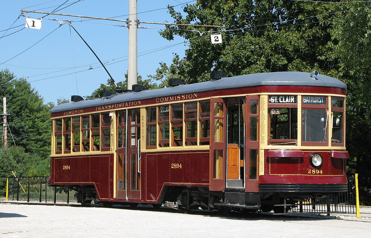 |
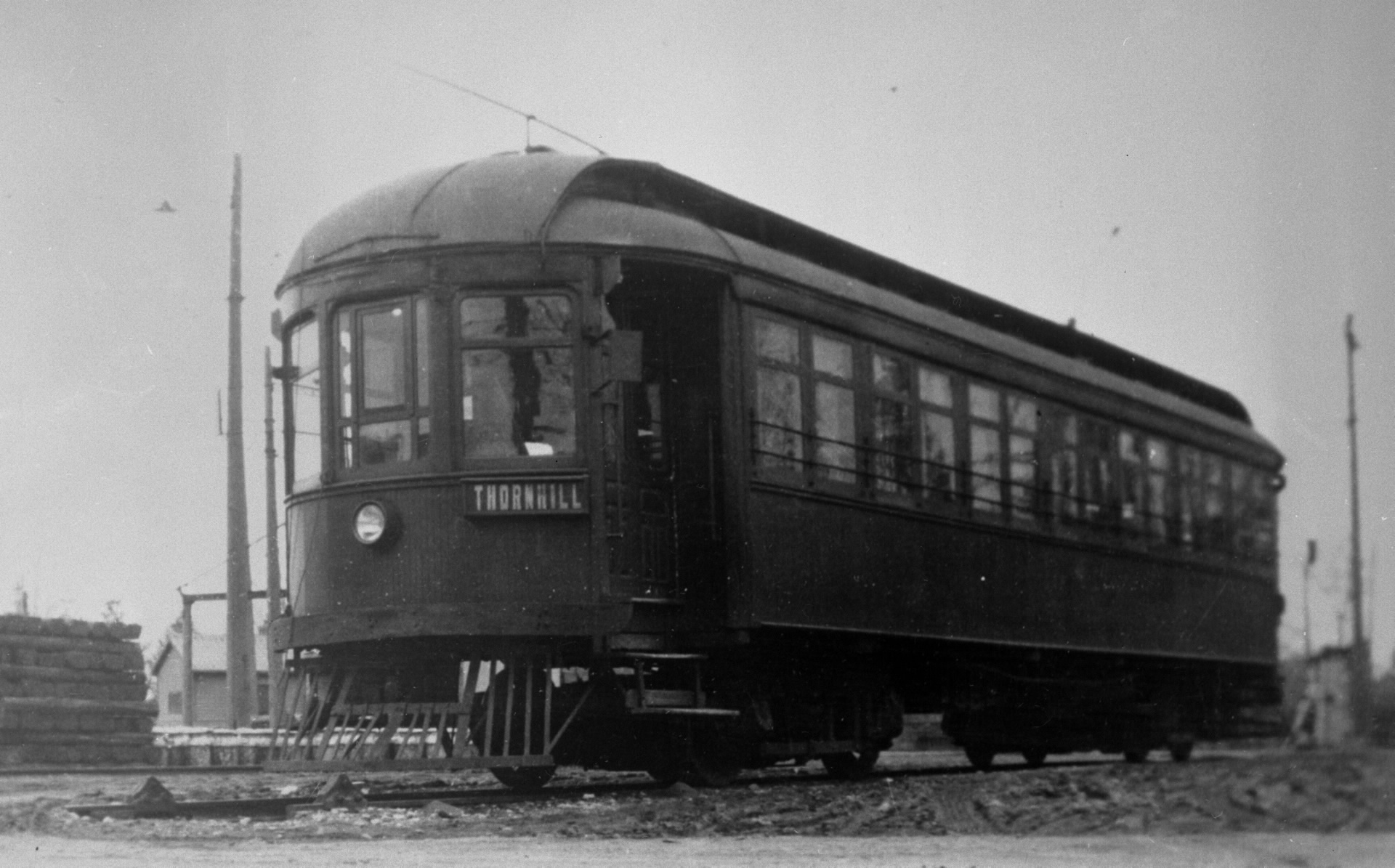 |
MAPS
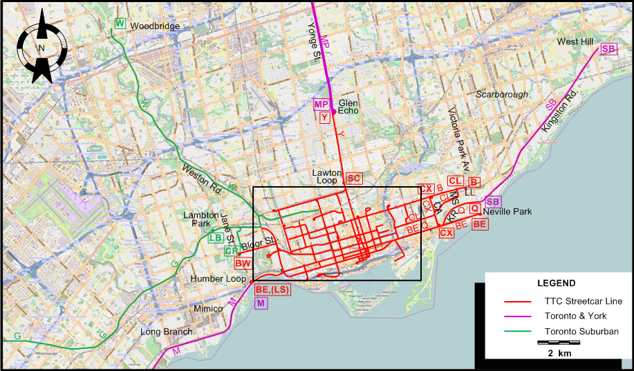
INSET: CENTRAL TORONTO
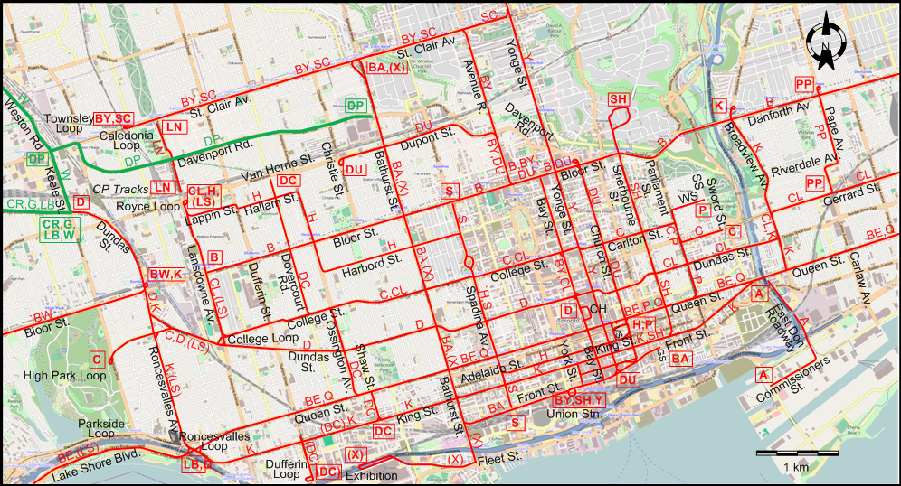
INSET: THE GREATER TORONTO AREA
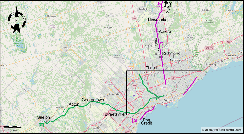
Interurban and suburban routes
ABBREVIATIONS ON THE MAPS
| CA | Coxwell Av. | MS | Main Street |
| CH | City Hall Loop | SS | Sumach St. |
| GS | George St. | VS | Victoria St. |
| KR | Kingston Rd. | WS | Winchester St. |
| LL | Luttrell Loop |
I created the above maps by overlaying OpenStreetMap (OSM) maps with my own data. The underlying map data is © OpenStreetMap contributors, licensed under the Open Database License (ODbL).
Please note that the OSM maps used as a template for these maps corresponds to the situation at the time the map was downloaded and may show features that did not exist at the time the GS Tram Site is supposed to show. In particular, it may show bridges and highways that were built later.
DISCONTINUATION DATES OF STREETCAR TRACKS BETWEEN 1 JULY 1923 AND WORLD WAR II [affected route indicators in parantheses]:
- 1923 Nov. 28: Gilmour Av. - Louisa St. [now St. Johns Rd.] - Fairview Av. - Evelyn Cr. (CR) [TSR route]
- 1924 Sept. 19: East Don Roadway - Commissioners St. (A)
- 1926: Weston - Woodbridge (W) [TSR route]
- 1928 Aug. 17: Runnymede Rd. - Dundas St. - Lambton Park (LB) [TSR route]
- 1931: Avenue Road (between Dupont St. and Bloor St.) (BY, DU)
- 1935 Feb. 9: Long Branch - Port Credit (Port Credit Line, formerly Mimico Line)
- 1935 Sept. 13: Guelph Interurban [TSR route]
ROUTES
URBAN STREETCAR ROUTES
Operator: Toronto Transit Commission (TTC)
Note: The lettered route designations are of an indicative nature only, they were never used as such. The official names of the routes are given in the second column in capitals.
| A | ASHBRIDGE | Queen St. - East Don Roadway - Commissioners St. |
| B | BLOOR | Lansdowne & Bloor - Bloor St. - Danforth Av. - Luttrell Loop |
| BA | BATHURST | George St. - Front St. - Bathurst St. - Bathurst & St. Clair (Vaughan Loop) |
| BE | BEACH | Humber Loop - Lake Shore Blvd. - Queen St. - Neville Park |
| BW | BLOOR WEST | Dundas W & Bloor - Bloor St. - Jane & Bloor |
| BY | BAY | Union Stn - Front St. - Bay St. - Bloor St. - Avenue Rd. - St. Clair Av. - Caledonia Loop |
| C | CARLTON | High Park Loop - College St. - Carlton St. - Parliament St. - Gerrard St. - Sword St. |
| CL | COLLEGE | Lansdowne & Dupont (Royce Loop) - Lansdowne Av. - College St. - Bay St. - Dundas St. - Broadway Av. - Gerrard St. - Main St. - Danforth & Main |
| CX | COXWELL | Coxwell & Danforth - Coxwell Av. - Coxwell & Queen |
| D | DUNDAS | City Hall Loop - Bay St. - Dundas St. - Keele & Dundas |
| DC | DOVERCOURT | Van Horne St. (now Dupont St.) - Dovercourt Rd. - College St. - Ossington Av. - Queen St. - Shaw St. - King St. |
| DF | DUFFERIN | King St. - Dufferin St. - Dufferin Loop [Rush hours only] |
| DU | DUPONT | Wellington & Yonge - Wellington St. [back: Front St.] - Church St. - Bloor St. - Avenue Rd . - Dupont St. - Christie Loop (Christie & Dupont) |
| H | HARBORD | Lansdowne & Dupont (Royce Loop) - Lansdowne Av. - Lappin St. - Dovercourt Rd. - Hallam St. - Ossington Av. - Harbord St. - Spadina Av. - Adelaide St. - Church Loop |
| K | KING | Dundas W & Bloor (Vincent Loop) - Roncesvalles Av. - King St. - Queen St. - Broadview Av. - Broadview & Danforth (Erindale Loop) |
| KR | KINGSTON ROAD | McCaul Loop - Queen St. - Kingston Rd. - Birchmount Loop |
| LN | LANDSDOWNE NORTH | CP Tracks - Landsdowne Av. - Landsdowne & St. Clair |
| LS | LANDSDOWNE SOUTH | Lansdowne & Dupont (Royce Loop) - Landsdowne Av. - Dundas St. - Roncesvalles Av. - Lake Shore Blvd. - Humber Loop - [Evening, Saturday afternoon and Sunday/Holiday service] |
| P | PARLIAMENT | Church Loop - Queen St. - Parliament St. - Winchester St. - Sumach St. |
| PP | PAPE | Gerrard St. - Carlaw Av. - Riverdale Av. - Pape Av. - Pape & Danforth |
| Q | QUEEN | Roncesvalles Loop - Queen St. - Kingston Rd. - Victoria Park Av. |
| S | SPADINA | Bloor & Spadina - Spadina Av. - Front & Spadina |
| SC | ST. CLAIR | Caledonia Loop - St. Clair Av. - Yonge St. - Lawton Loop |
| SH | SHERBOURNE | Rosedale (Elm, Glen Road & South Drive) - Sherbourne St. - King St. - Union Station |
| X | EXHIBITION | Exhibition - Fleet St. - Bathurst St. - Bathurst & St. Clair (Vaughan Loop) [During the Canadian National Exhibition (CNE) only] |
| Y | YONGE | Union Station - Front St. - Yonge St. - City Limits (Glen Echo) |
INTERURBAN STREETCAR ROUTES
Operator: Toronto & York Radial lines
| M | MIMICO | Humber Loop - Mimico - Long Branch - Port Credit |
| MP | METROPOLITAN | Glen Echo - Yonge St. - Thornhill - Richmond Hill - Aurora - Newmarket - Sutton (Lake Simcoe) |
| SB | SCARBORO | Victoria Park Av. - Kingston Rd. - West Hill |
The Mimico line was managed by the Ontario Hydro-Electric Power Commission.
SUBURBAN STREETCAR ROUTES
Operator: Toronto Suburban Railway (TSR)
| CR | CRESCENT | Keele & Dundas - Dundas St. - Gilmour Av. - Louisa St. [now St. Johns Rd.] - Fairview Av. - Evelyn Cr. |
| DP | DAVENPORT | Bathurst St. - Davenport Rd. - St. Clair Av. - Weston Rd. |
| G | GUELPH | Keele & Dundas - Dundas St. - Lambton - Streetsville - Georgetown - Acton - Guelph |
| LB | LAMBTON | Keele & Dundas - Dundas St. - Lambton Park |
| W | WESTON ROAD | Keele & Dundas - Keele St. - Weston Rd. - Woodbridge |
CHARACTERISTICS OF THE SYSTEM
NETWORK LENGTH
- Urban streetcars: ? km.
- Interurban/Suburban streetcar lines: ? km.
HISTORY
- Urban treetcars: (horse-powered) 11 Sept. 1861 - 30 Aug. 1894; (electric) 15 Aug. 1892 - today.
- Interurban streetcars: (horse-powered) 26 Jan. 1885 - 1890; (electric, on Yonge North) 1 Sept. 1890 - 10 Oct. 1948; (electric, to the Humber River, then to Mimico & Port Credit) 16 July 1892 - 27 Sept. 1928.
- LRT (Scarborough Rapid Transit): 22 Mar. 1985 - 24 July 2023.
- LRT (Finch West): 7 Dec. 2025 - today.; (Eglinton): 8 Feb. 2026 - today.
- Subway: 30 Mar. 1954 - today.
GAUGE
- Urban streetcars (Toronto): 1495 mm.
- Light rail: 1435 mm.
- Interurban streetcars: 1435 mm. (1885 - 1927); 1495 mm. (1927 - 1948).
- Toronto Suburban Railway (TSR): 1435 mm.
- LRT (Scarborough Rapid Transit; Finch West): 1435 mm.
- Subway: 1495 mm.
SOURCES
- Bromley, J.F. TTC '28: The electric railway services of the Toronto Transportation Commission in 1928. Toronto: Upper Canada Railway Society, 1968.
- Filey, M. Not a one-horse town: 125 years of Toronto and its streetcars. Toronto: [Author], 1986.
- Filey, M. The TTC story: The first seventy-five years. Toronto/Oxford: Dundurn Press, 1996.
- Simons, V. "Toronto: Making the move", Tramways & Urban Transit, Oct. 2013 (76:910), p.420-426.
- Skelsey, G. "Toronto: The TTC's streetcars at 80 (Part 4)", Tramways & Urban Transit, Jan. 2001 (64:757), p.15-18.
- Taplin, M.R. Tramways of North America, including rapid transit.Hassocks (England): Light Rail Transit Association, 1982 (?).
- Wickson, E.A. "Toronto's new Light Rail Line". In: Light Rail Review 2. London: Light Rail Transit Association, 2000 [p.63-65].
WIKIS
- Line 3 Scarborough
- Line 5 Eglinton
- Line 6 Finch West
- Metrolinx
- Metropolitan line (Toronto)
- North Yonge Railways
- Toronto and York Radial Railway
- Toronto streetcar system
- Toronto Suburban Railway
- Toronto subway
- Toronto Transit Commission
WEB SITES
- Canadian Street Railways
- Metrolinx
- Steve Munro's Web Site (dedicated to public transit in Toronto)
- Toronto (on UrbanRailNet)
- Toronto Transit Commission (TTC)
- Transit Toronto
- TTS (Toronto Transportation Society) Online
Copyright Gabor Sandi 1998-2026
Disclaimer: Everything on this site was written and/or prepared at the author's discretion. The author has tried to be accurate where facts are presented, but this does not mean that these facts are necessarily accurate. People needing more reliable information should refer to appropriate sources presented, on the Internet or elsewhere, by authoritative professional or academic bodies.
To get in touch with the webmaster, send an e-mail to g_sandi at hotmail.com.
Flags on this site are from the FOTW Flags Of The World website.