VIDEOS
 |
 |
| Above: YouTubeCA video - Hiroshima trams - Length: 9:02 mins. | Above: YouTubeCA video - Hiroshima Rapid Transit "Astram Line - Length: 10:00 mins. |
PHOTOS
 |
 |
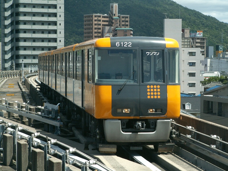 |
MAP
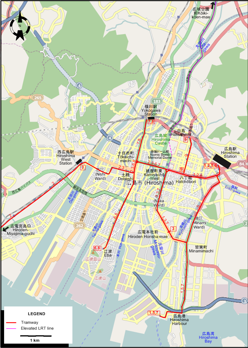
I created the above map by overlaying an OpenStreetMap (OSM) map with my own data. Copyright on the OSM map is © OpenStreetMap contributors, licensed under a CC-BY-SA (Creative Commons Attribution-ShareAlike 2.0 licence).
Please note that the OSM map used as a template for this map corresponds to the situation at the time the map was downloaded and may show features that did not exist at the time the GS Tram Site is supposed to show. In particular, it may show bridges and highways that were built later.
ROUTES
TRAM ROUTES
Operator: 広島電鉄株式会社 (Hiroshima Electric Railway)
| 1 | 広島駅 (Hiroshima Station) – 八丁堀 (Hatchōbori) – 紙屋町東 (Kamiyachō-West) – 広電本社前 (Hiroden Honsha-mae) - 皆実町 (Minamimachi) – 広島港 (Hiroshima Harbour) |
| 2 | 広島駅 (Hiroshima Station) – 八丁堀 (Hatchōbori) – 紙屋町東 (Kamiyachō-West) – 原爆ドーム前 (Atomic Bomb Memorial Dome) – 十日市町 (Tōkaichi-machi) – 土橋 (Dobashi) – 西広島駅 (Hiroshima West Station) – 広電宮島口 (Hiroden-Miyajima-guchi) |
| 3 | 広電本社前 (Hiroden Honsha-mae) – 紙屋町東 (Kamiyachō-West) – 原爆ドーム前 (Atomic Bomb Memorial Dome) – 十日市町 (Tōkaichi-machi) – 土橋 (Dobashi) – 西広島駅 (Hiroshima West Station) |
| 5 | 広島駅 (Hiroshima Station) – 皆実町 (Minamimachi) – 広島港 (Hiroshima Harbour) |
| 6 | 広島駅 (Hiroshima Station) – 八丁堀 (Hatchōbori) – 紙屋町東 (Kamiyachō-West) – 原爆ドーム前 (Atomic Bomb Memorial Dome) – 十日市町 (Tōkaichi-machi) – 土橋 (Dobashi) – 江波 (Eba) |
| 7 | 広島港 (Hiroshima Harbour) – 皆実町 (Minamimachi) – 広電本社前 (Hiroden Honsha-mae) - 紙屋町東 (Kamiyachō-West) – 原爆ドーム前 (Atomic Bomb Memorial Dome) – 十日市町 (Tōkaichi-machi) – 横川駅 (Yokogawa Station) |
| 8 | 横川駅 (Yokogawa Station) – 十日市町 (Tōkaichi-machi) – 土橋 (Dobashi) – 江波 (Eba) |
| 9 | 八丁堀 (Hatchōbori) – 白島 (Hakushima) |
ELEVATED LRT LINE
Operator: 広島高速交通株式会社 (Hiroshima Rapid Transit)
| 紙屋町東 (Kamiyachō-West – 白島 (Hakushima) – 広域公園前 (Kōiki-kōen-mae) |
CHARACTERISTICS OF THE SYSTEM
NETWORK LENGTH
- Tram lines: 35 km. (of which an original interurban line, now part of line 2: 16 km.)
- Elevated rapid transit (Astram line): 18.4 km.
HISTORY
- Municipal tramway: 23 Nov. 1912 - today.
- Interurban tramway (Miyajima line, later integrated into the municipal system): 22 Aug. 1922 - today.
- Elevated rapid transit (Astram line): 8 Aug. 1994 - today.
GAUGE
- Municipal tramway: 1435 mm.
- Interurban tramway (later integrated into the municipal system): 1435 mm.
- Elevated rapid transit (Astram line): Automated guideway line
SOURCES
- Demery, L.W., Forty, R., De Groote, R. and Higgins, J.W. Electric railways of Japan - Vol.3: Western Japan. Gloucester (England): Light Rail Transit Association, 1997.
- Forty, R. and Higgins, J.W. "Japan today (Part 4: Honshu's western outposts)", Modern Tramway and Light Rail Transit, May. 1977 (40:473), p.160-166.
- 原口隆行 (Haraguchi, T.) 日本の路面電車 I (Japan's Street Railways, Pt.I). Tokyo: JTB, 2000.
- 長船友則 (Osafune,T.) 広電が走る街・今昔 (The city where the Hiroshima Electric Railway runs - Past and present). Tokyo: JTB, 2005.
- Suffolk, D. "Hatching phoenix eggs: Hiroshima leads the way in Japanese LRT development". In: Light Rail Review 3. London: Light Rail Transit Association, 2001 [p.65-66].
WIKIS
WEB SITES
- 広島電鉄株式会社 (Hiroshima Electric Railway)
- 広島高速交通株式会社 (Hiroshima Rapid Transit)
- 広島電鉄資料館 (Hiroshima trams)
Copyright Gabor Sandi 1998-2025
Disclaimer: Everything on this site was written and/or prepared at the author's discretion. The author has tried to be accurate where facts are presented, but this does not mean that these facts are necessarily accurate. People needing more reliable information should refer to appropriate sources presented, on the Internet or elsewhere, by authoritative professional or academic bodies.
To get in touch with the webmaster, send an e-mail to g_sandi at hotmail.com.
Flags on this site are from the FOTW Flags Of The World website.