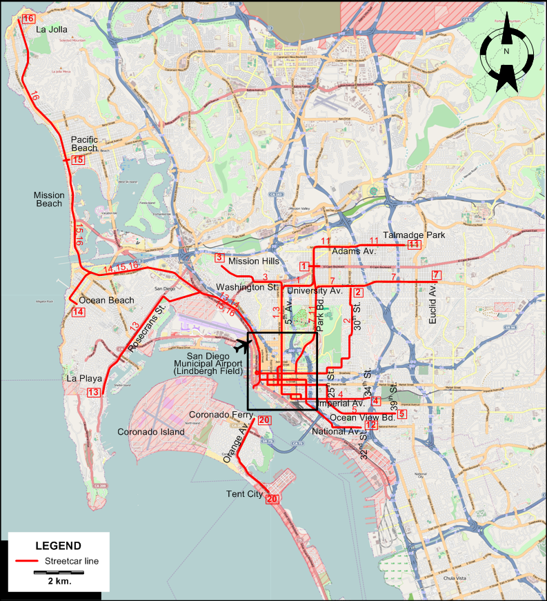
INSET: CENTRAL SAN DIEGO
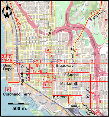
STREETCAR ROUTES
Operator: San Diego Electric Railway (SDERy)
| 1 |
5th & Market - 5th Av. - University Av. - Park Bd. (El Cajon Av.) |
| 2 |
Union Depot - Broadway - 30th St. - 30th & University |
| 3 |
5th & Market - 5th Av. - Washington St. - Mission Hills |
| 4 |
5th & B Av. - 5th Av. - K Street - Imperial Av. - 34th & Imperial |
| 5 |
Union Depot - State St. - Market St. - 25th St. - Ocean View Bd. - 39th & Ocean View |
| 7 |
Union Depot - Broadway - 12th Av. - Balboa Park - Park Bd. - University Av. - Euclid Av. & University |
| 9 |
Coronado Ferry - Market St. - Kettner Bd. - Broadway - 5th Av. - F Street - Kettner Bd. - Market St. - Coronado Ferry
[Loop route, clockwise] |
| 11 |
Union Depot - Broadway - 12th Av. - Balboa Park - Park Bd. - Adams Av. - Talmadge Park |
| 12 |
Union Depot - Kettner Bd. - F Street - 16th St. - Logan Av. - National Av. - 32nd St. & National |
| 13 |
Union Depot - Kettner Bd. - Rosecrans St. - La Playa |
| 14 |
Union Depot - Kettner Bd. - Ocean Beach |
| 15 |
Union Depot - Kettner Bd. - Mission Beach - Pacific Beach |
| 16 |
Union Depot - Kettner Bd. - Mission Beach - Pacific Beach - La Jolla |
| 20 |
Coronado Island line (Ferry - Orange Av. - Tent City) |
Some of the downtown routing above is based on educated guesswork, as the sources I have at my disposal do not allow for an exact
description of the routes in the area.
CHARACTERISTICS OF THE SYSTEM
NETWORK LENGTH
I am particularly thankful to the staff of the Document Archives at the San Diego History
Center in beautiful Balboa Park, without whose helpful assistance in locating relevant maps and street guides I would not have been able to prepare this page.
|