THE GS TRAM SITE

MINNEAPOLIS - ST.PAUL

MINNESOTA, UNITED STATES

flag.us

14 Nov. 2009

(Up-to-date)

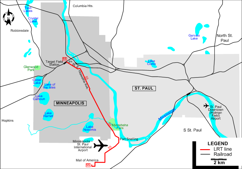
The twin cities after the rebirth of rail-based urban transit in 2004.


UNITED STATES

LOS ANGELES

MINNEAPOLIS - ST. PAUL

PHOENIX

PORTLAND

SACRAMENTO

SAN DIEGO

SAN FRANCISCO

SAN JOSÉ

SEATTLE - TACOMA

WASHINGTON


GS Web Site Home


Minneapolis LRT Minneapolis LRT

Minneapolis LRT  map –  2009


LIGHT RAIL ROUTE

Operator: Metro Transit

55 Hiawatha Line Target Field Station – 5th St. S – Hiawatha Ave. – Fort Snelling – Minneapolis-St. Paul International Airport – Mall of America

CHARACTERISTICS OF THE SYSTEM

NETWORK LENGTH

  • Streetcar lines: 20 km.


HISTORY

  • Streetcars:
    • Horse-powered: St. Paul: July 1872 - 1892; Minneapolis: 2 Sept. 1875 - 1892.
    • Electric: Minneapolis: 24 Dec. 1889 - 19 June 1954; St. Paul: 22 Feb. 1890 - 31 Oct. 1953.
  • Light rail (Hiawatha Line): 26 June 2004 - today.

GAUGE

  • 1435 mm.

TRAM PRESERVATION

The Minnesota Streetcar Museum runs historic Minneapolis - St. Paul streetcars at two museum locations: adjacent to Lake Harriet in SW Minneapolis and at Excelsior, 15 miles (24 km) west of Minneapolis.


SOURCES

PRINT

  • Carter, J.M. "Minnesota: Streetcar named conspire", Tramway & Urban Transit, Nov. 2003 (66: 791), p.413-415.
  • Diers, J.W. & Isaacs, A. Twin City Trolley: The streetcar era in Minneapolis and St. Paul Minneapolis & London: University of Minnesota Press, 2007.

WIKIS

WEB SITES


Hit count for the GS Tram Site:

Valid HTML 4.01!


Copyright Gabor Sandi 1998-2010

To get in touch with the webmaster, send an e-mail to g_sandi@hotmail.com

Flags on this site are from the FOTW Flags Of The World website.