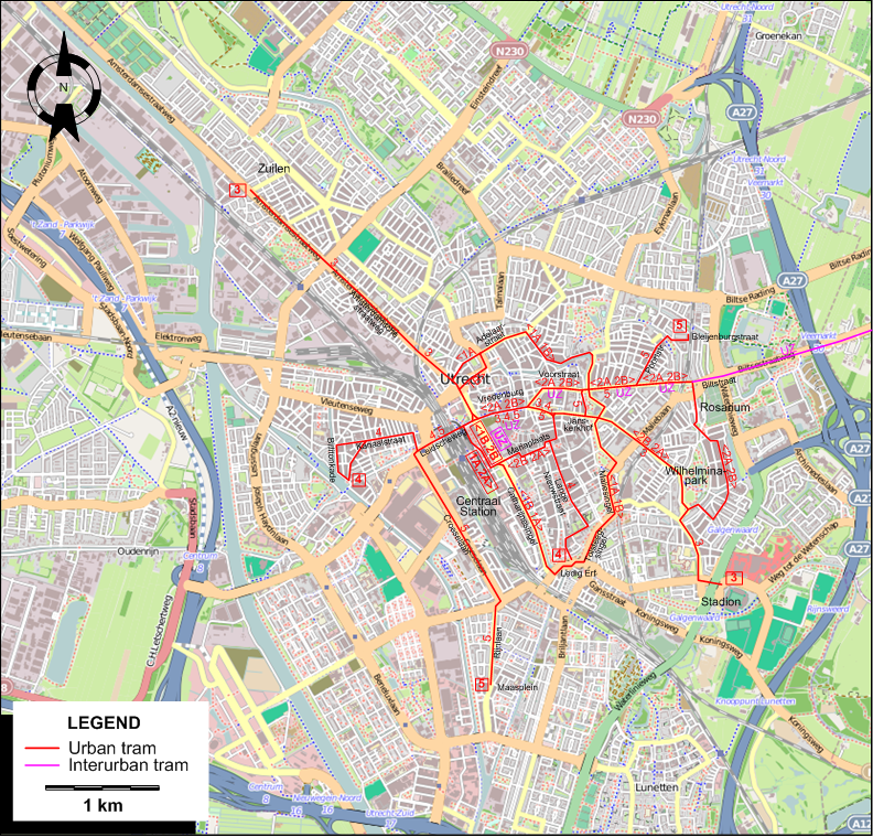
URBAN TRAM ROUTES
Operator: Gemeentelijk Trambedrijf Utrecht (GTU)
| 1 |
Centraal Station - Catharijnesingel - Tolsteegsingel - Maliesingel - Adelaarstraat - Amsterdamsche straatweg - Centraal Station [Circular route,
both directions: 1A - anticlockwise, 1B - clockwise] |
| 2 |
Centraal Station - Mariaplaats - Janskerkhof - Wilhelminapark - Rosarium - Biltstraat - Voorstraat - Vredenburg - Centraal Station [Circular route,
both directions: 2A - anticlockwise, 2B - clockwise] |
| 3 |
Zuilen - Amsterdamsche straatweg - Vredenburg - Janskerkhof - Wilhelminapark - Stadion |
| 4 |
Ledig Erf - Lange Nieuwstraat - Vredenburg - Leidscheweg - Kanaalstraat - Billitonkade |
| 5 |
Bleijenburgstraat - Poortstraat - Biltstraat - Janskerkhof - Vredenburg - Leidscheweg - Croeselaan - Rijnlaan - Maasplein |
INTERURBAN TRAM ROUTE
Operator: Nederlandsche Buurtspoorweg-Maatschappij (NBM)
| UZ |
Centraal Station - Vredenburg - Voorstraat - Biltstraat - Zeist |
Note: The route designation UZ is for convenience only, and was not used by the operator.
CHARACTERISTICS OF THE SYSTEM
NETWORK LENGTH
- Urban trams: ? km.
- Interurban trams: ? km.
|