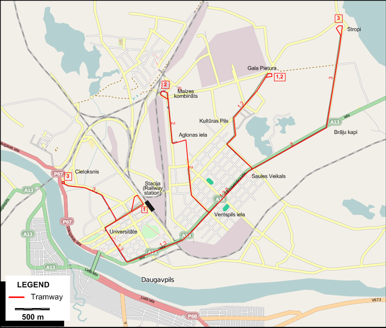
I created the above map by overlaying an OpenStreetMap (OSM) map with my own data. Copyright on the OSM map is ©
OpenStreetMap & Contributors, licensed under a CC-BY-SA (Creative Commons Attribution-ShareAlike 2.0 licence).
Please note that the OSM map used as a template for this map corresponds to the situation at the time the map was downloaded and may show features that did not exist at the time
the GS Tram Site is supposed to show. In particular, it may show bridges and highways that were built later.
ROUTES
TRAM ROUTES
Operator: Rīgas Satiksme
| 1 |
Gala Pietura - Kultūras Pils - Saules Veikals - Ventspils iela - Universitāte - Stacija (Railway station) |
| 2 |
Gala Pietura - Kultūras Pils - Saules Veikals - Ventspils iela - Aglonas iela - Maizes kombināts |
| 3 |
Stropi - Saules Veikals - Saules Veikals - Ventspils iela - Universitāte - Cietoksnis |
CHARACTERISTICS OF THE SYSTEM
NETWORK LENGTH
HISTORY
- Urban tramways: 5 Nov. 1946 - today
GAUGE
SOURCES
PRINT
- Straßenbahnatlas ehem. Sowjetunion - Tramway atlas of the former USSR. Berlin: Arbeitsgemeinschaft Blickpunkt Straßenbahn / London: Light
Rail Transit Association, 1996.
WIKIS
WEB SITES
|