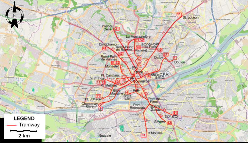
ABBREVIATIONS ON THE MAP
| PdR |
Place de la République |
PR |
Place Royale |
| PM |
Pont Morand |
PSP |
Place St.Pierre |
TRAM ROUTE
Operator: Compagnie des tramways de Nantes
| 1 |
Chantenay Gare - Gare Maritime - Commerce - Gare C.F.A. & P.O. - Dalby - Doulon |
| 4 |
Gare Etat - Place de la République - Commerce - Gare C.F.A. & P.O. |
| 11 |
Pl. E.Zola - Pl. Mellinet - Pl. Royale - Pl. St.Pierre - Rond-Point de Paris - St. Joseph |
| 12 |
Pl. E.Zola - Pl. Mellinet - Pl. Royale - Pl. St.Pierre - Rond-Point de Paris |
| 21 |
Pl. J.Macé - Pl. Mellinet - Pl. Canclaux - Gare C.F.A. & P.O. - Dalby |
| 26 |
Pl. Mellinet - Pl. Canclaux - Pont Morand - Michelet |
| 31 |
Pont du Cens - Rond-Point de Rennes - Pont Morand - Commerce - Place de la République - Pont de Pirmil -
Pont-Rousseau - 3 Moulins |
| 41 |
Longchamp - Rond-Point de Vannes - Pont de Pirmil - Bonne Garde - Lion d'Or |
| 43 |
Rond-Point de Vannes - Pont de Pirmil - Bonne Garde - Sèvres |
| 51 |
Monselet - Commerce - Pont Morand - Rond-Point de Rennes - La Morrhonnière |
| 52 |
Monselet - Commerce - Pont Morand - Michelet - La Morrhonnière |
NETWORK LENGTH
|