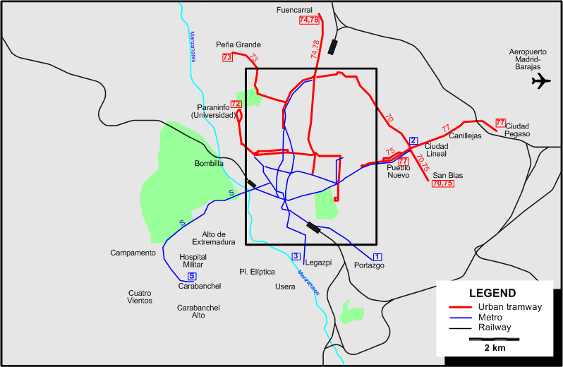
INSET: DOWNTOWN MADRID
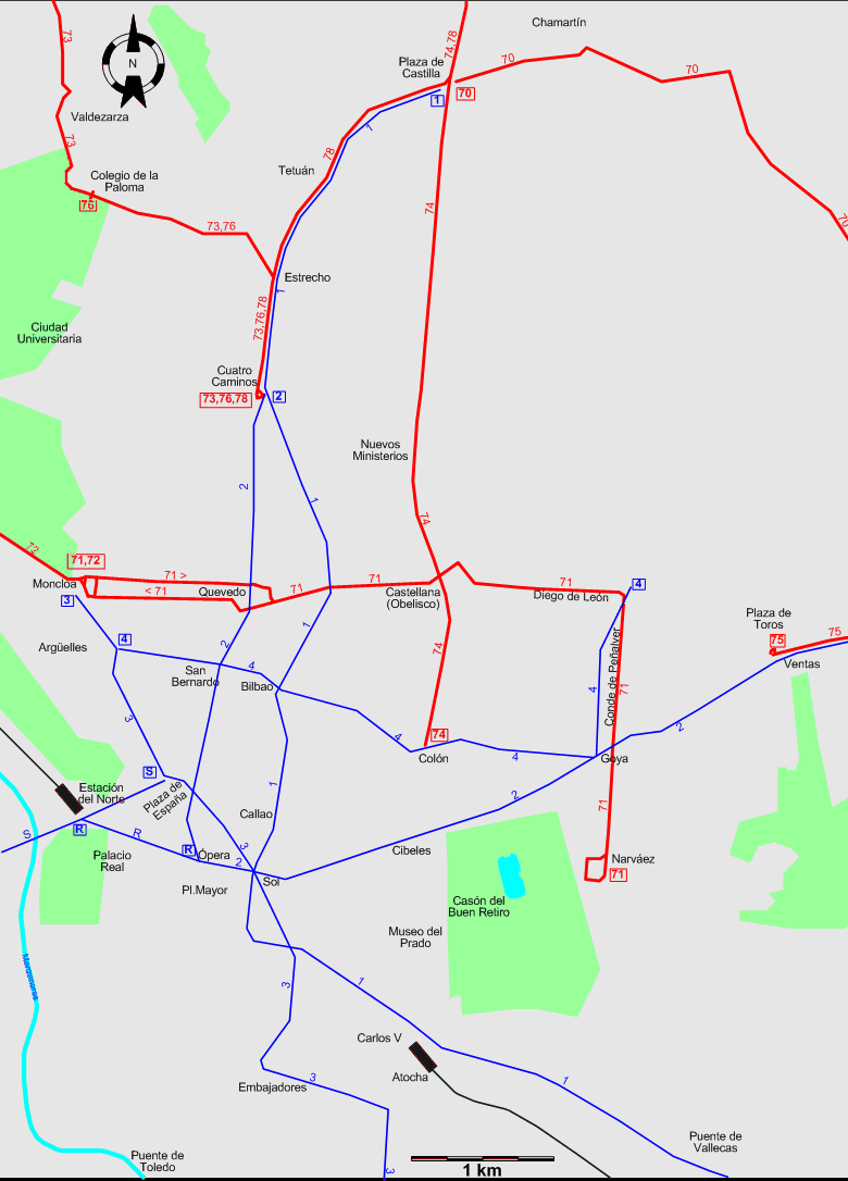
Chronology of major track abandonments and route number changes between 1964 and 1967
- Atocha - Usera (route 37) and Atocha - Cibeles (part of route 14): 1 Aug. 1965
- Complete renumbering of routes: 1 Aug. 1965
- Cibeles - Colón (part of route 74): 11 Sept. 1966
- Quevedo - Cuatro Caminos (part of route 76): 19 Dec. 1966
ROUTES
TRAM ROUTES
Operator: Sociedad Madrileña de Tranvías (S.M.T.) (predecessor of Empresa Municipal de Transportes de Madrid (E.M.T.))
| 70 |
Plaza de Castilla – Chamartín – Ciudad Lineal – San Blas |
| 71 |
Moncloa – Quevedo – Iglesia – Castellana – Diego de León – Conde de Peñalver – Goya – Narváez |
| 72 |
Moncloa – Paraninfo (Universidad) |
| 73 |
Cuatro Caminos – Estrecho – Colegio de la Paloma – Valdezarza – Peña Grande |
| 74 |
Colón – Castellana – Nuevos Ministerios – Plaza de Castilla – Fuencarral |
| 75 |
Ventas – Pueblo Nuevo – Ciudad Lineal – San Blas |
| 76 |
Cuatro Caminos – Estrecho – Colegio de la Paloma |
| 77 |
Pueblo Nuevo – Ciudad Lineal – Canillejas – Ciudad Pegaso |
| 78 |
Cuatro Caminos – Estrecho – Tetuán – Plaza de Castilla – Fuencarral |
UNDERGROUND (METRO) ROUTES
Operator: Compañía Metropolitana de Madrid
| 1 |
Plaza de Castilla – Tetuán – Cuatro Caminos – Bilbao – Sol – Atocha – Puente de Vallecas – Portazgo |
| 2 |
Cuatro Caminos – Quevedo – Ópera – Sol – Cibeles (Banco de España) – Goya – Ventas – Pueblo Nuevo – Ciudad Lineal |
| 3 |
Moncloa – Argüelles – Pl. de España – Sol – Embajadores – Delicias – Legazpi |
| 4 |
Argüelles – San Bernardo – Bilbao – Colón – Goya – Diego de León |
| R |
Ópera – Estación del Norte [Shuttle] |
| S |
[Suburbano] Plaza de España – Estación del Norte – Campamento – Carabanchel |
Note: Line S (also known as Suburbano), constructed by the state and opened on 4 Feb. 1961, was owned by a different entity, but managed by the Compañía Metropolitana de Madrid
CHARACTERISTICS OF THE SYSTEM
NETWORK LENGTH
- Tramways: 93 km.
- Metro: ? km.
|