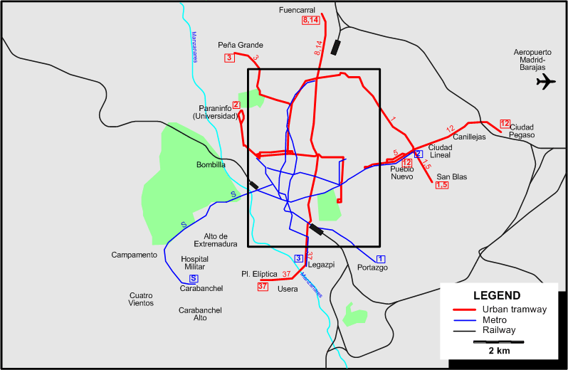
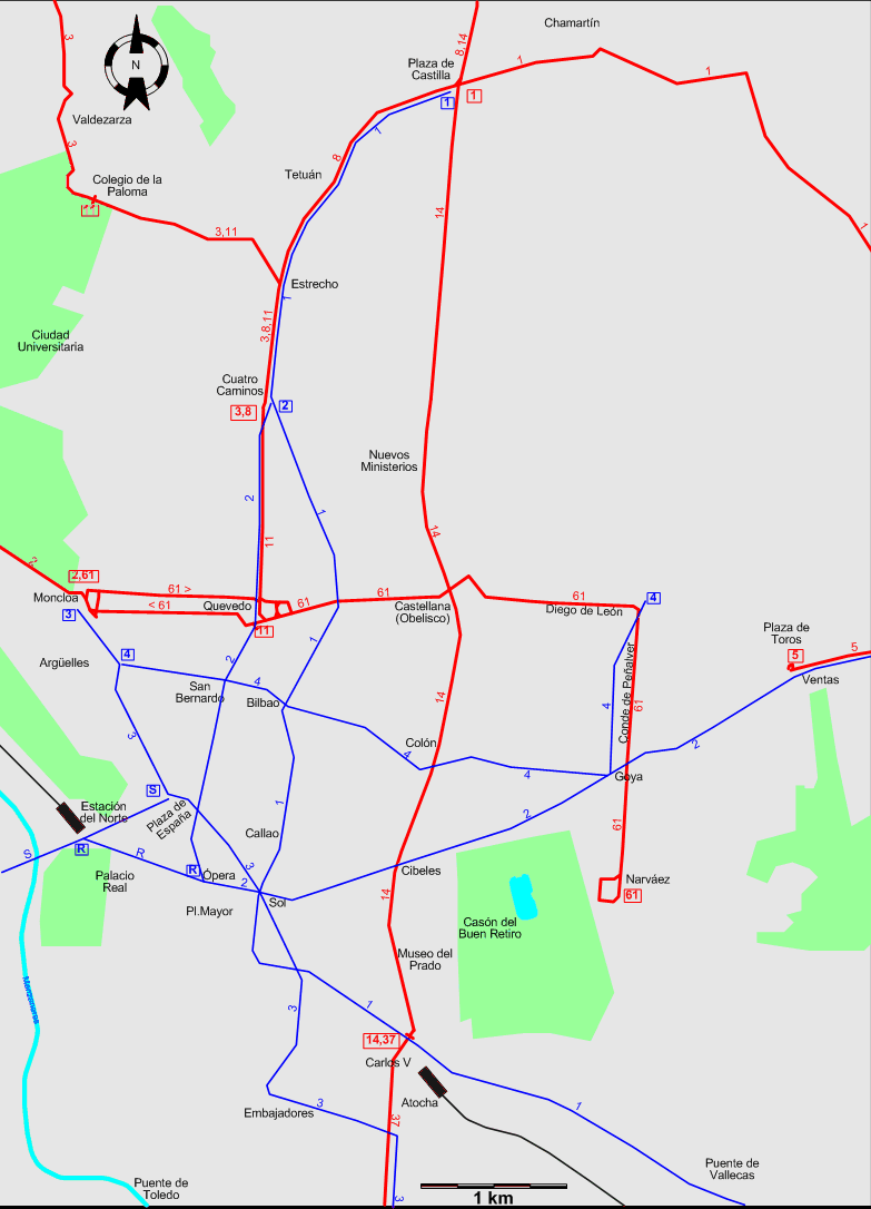
INSET: DOWNTOWN MADRID
Chronology of major track abandonments between 1958 and 1964
- Most of the Calle de Velázquez: 2 Apr. 1958
- The Princesa - Palacio Real area: 20 Aug. 1958
- On the last remaining route in the city centre (Calle de Atocha) and on Alcalá between Independencia and Goya: 10 Sept. 1958
- On Calle de Goya and on Alcalá between Goya and Becerra: 9 Aug. 1959
- On the Paseo de La Habana (Line No.7): 15 Aug. 1959
- On the Ciudad Jardín route and on Alfonso XIII: 18 Feb. 1962
- On Trafalgar and the Atocha - Puente de Vallecas segment: 9 Aug. 1962
- On Santa Engracia: 14 Sept. 1963
- On the SW suburban routes to Cuatro Vientos, using the Puente de Segovia: 18 Aug. - 5 Sept. 1963
- What was left of the SW network in the Puerta de Toledo area and of the suburban route to Carabanchel Alto: 21-28 July 1964
ROUTES
TRAM ROUTES
Operator: Sociedad Madrileña de Tranvías (S.M.T.) (predecessor of Empresa Municipal de Transportes de Madrid (E.M.T.))
| 1 |
Plaza de Castilla – Chamartín – Ciudad Lineal – San Blas |
| 2 |
Moncloa – Paraninfo (Universidad) |
| 3 |
Cuatro Caminos – Estrecho – Colegio de la Paloma – Valdezarza – Peña Grande |
| 5 |
Ventas – Pueblo Nuevo – Ciudad Lineal – San Blas |
| 8 |
Cuatro Caminos – Estrecho – Tetuán – Plaza de Castilla – Fuencarral |
| 11 |
Quevedo – Cuatro Caminos – Estrecho – Colegio de la Paloma |
| 12 |
Pueblo Nuevo – Ciudad Lineal – Canillejas – Ciudad Pegaso |
| 14 |
Carlos V (Atocha) – Museo del Prado – Cibeles – Colón – Castellana – Nuevos Ministerios – Plaza de Castilla – Fuencarral |
| 37 |
Carlos V (Atocha) – Legazpi – Usera – Plaza Elíptica |
| 61 |
Moncloa – Quevedo – Iglesia – Castellana – Diego de León – Conde de Peñalver – Goya – Narváez |
UNDERGROUND (METRO) ROUTES
Operator: Compañía Metropolitana de Madrid
| 1 |
Plaza de Castilla – Tetuán – Cuatro Caminos – Bilbao – Sol – Atocha – Puente de Vallecas – Portazgo |
| 2 |
Cuatro Caminos – Quevedo – Ópera – Sol – Cibeles (Banco de España) – Goya – Ventas – Pueblo Nuevo – Ciudad Lineal |
| 3 |
Moncloa – Argüelles – Pl. de España – Sol – Embajadores – Delicias – Legazpi |
| 4 |
Argüelles – San Bernardo – Bilbao – Colón – Goya – Diego de León |
| R |
Ópera – Estación del Norte [Shuttle] |
| S |
[Suburbano] Plaza de España – Estación del Norte – Campamento – Carabanchel |
Note: Line S (also known as Suburbano), constructed by the state and opened on 4 Feb. 1961, was owned by a different entity, but managed by the Compañía Metropolitana de Madrid
CHARACTERISTICS OF THE SYSTEM
NETWORK LENGTH
- Tramways: 108 km.
- Metro: ? km.
|