ABBREVIATIONS ON THE MAP
| KP |
Karlsplatz |
MxP |
Maximiliansplatz |
| MWP |
Max-Weber-Platz |
ST |
Sendlinger Tor |
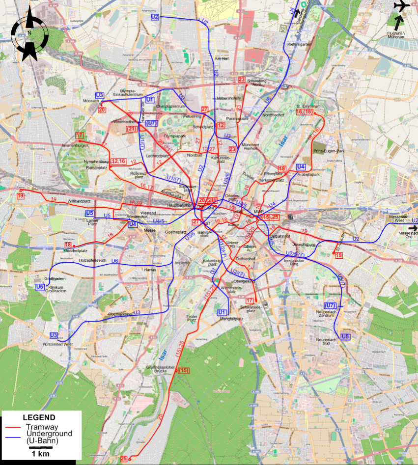
ROUTES
Operator: Münchner Verkehrsgesellschaft mbH (MVG)
TRAM ROUTES
| 12 |
Nymphenburg (Romanplatz) - Neuhausen - Rotkreuzplatz - Leonrodplatz - Nordbad - Kurfürstenplatz - Scheidplatz |
| 15 |
Max-Weber-Platz - Obere Au - Ostfriedhof - Wettersteinplatz - Tiroler Platz - Giesing - Harlaching - Großhesseloher Brücke [peak hours only] |
| 16 |
Nymphenburg (Romanplatz) - Arnulfstraße - Hauptbahnhof (Main Station) - Sendlinger Tor - Isarvorstadt - Max-Weber-Platz -
Herkomerplatz - Effnerplatz - Arabellapark - Prinz-Eugen-Park - St. Emmeram |
| 17 |
Amalienburgstr. - Nymphenburg (Romanplatz) - Arnulfstraße - Hauptbahnhof (Main Station) - Sendlinger Tor - Isarvorstadt - Untere Au -
Ostfriedhof - Obergiesing - Schwanseeplatz |
| 18 |
Gondrellplatz - Westendstr. - Westend - Hauptbahnhof (Main Station) - Karlsplatz - Sendlinger Tor - Isarvorstadt - Lehel -
Tivolistr. - Herkomerplatz - Effnerplatz [at peak hours: - Arabellapark - Prinz-Eugen-Park - St. Emmeram] |
| 19 |
St.-Veit-Str. - Berg am Laim - Ostbahnhof - Max-Weber-Platz - Lehel - Maximiliansplatz - Karlsplatz - Hauptbahnhof (Main Station) - Westend - Willibaldplatz - Pasing |
| 20 |
Karlsplatz - Hauptbahnhof (Main Station) - Stiglmaierplatz - Leonrodplatz - Westfriedhof - Moosach |
| 21 |
Karlsplatz - Hauptbahnhof (Main Station) - Stiglmaierplatz - Leonrodplatz - Westfriedhof (Hanauer Str.) [peak times only] |
| 23 |
Münchner Freiheit - Parzivalplatz - Schwabing Nord |
| 25 |
Max-Weber-Platz - Obere Au - Ostfriedhof - Wettersteinplatz - Tiroler Platz - Giesing - Harlaching -
Großhesseloher Brücke - Grünwald |
| 27 |
Petuelring - Nordbad - Kurfürstenplatz - Karlsplatz - Sendlinger Tor |
UNDERGROUND (U-BAHN) ROUTES
| U1 |
Olympia-Einkaufszentrum - Westfriedhof - Rotkreuzplatz - Stiglmaierplatz - Hauptbahnhof (Main Station) -
Sendlinger Tor - Kolumbusplatz - Wettersteinplatz - Mangfallplatz |
| U2 |
Feldmoching - Hasenbergl - Am Hart - Scheidplatz - Hauptbahnhof (Main Station) - Sendlinger Tor - Kolumbusplatz - Obergiesing -
Innsbrucker Ring - Josephsburg - Trudering - Messestadt West - Messestadt Ost |
| U3 |
Moosach - Olympia-Einkaufszentrum - Olympiazentrum - Scheidplatz - Münchner Freiheit - Odeonsplatz - Sendlinger Tor - Goetheplatz -
Implerstraße - Thalkirchen - Obersendling - Fürstenried West |
| U4 |
Westendstraße - Hauptbahnhof (Main Station) - Karlsplatz - Odeonsplatz - Lehel - Max-Weber-Platz - Arabellapark |
| U5 |
Laimer Platz - Westendstraße - Hauptbahnhof (Main Station) - Karlsplatz - Odeonsplatz - Lehel - Max-Weber-Platz -
Ostbahnhof - Innsbrucker Ring - Neuperlach Zentrum - Neuperlach Süd |
| U6 |
Garching-Forschungszentrum - Kieferngarten - Nordfriedhof - Münchner Freiheit - Odeonsplatz - Sendlinger Tor - Goetheplatz - Implerstraße - Harras - Holzapfelkreuth - Großhadern - Klinikum Großhadern |
| U7 |
Westfriedhof - Rotkreuzplatz - Stiglmaierplatz - Hauptbahnhof (Main Station) -
Sendlinger Tor - Kolumbusplatz - Obergiesing - Innsbrucker Ring - Neuperlach Zentrum [peak times only] |
CHARACTERISTICS OF THE SYSTEM
NETWORK LENGTH
- Tramway: ca. 80 km.
- Underground (U-Bahn): ca. 103 km.
|