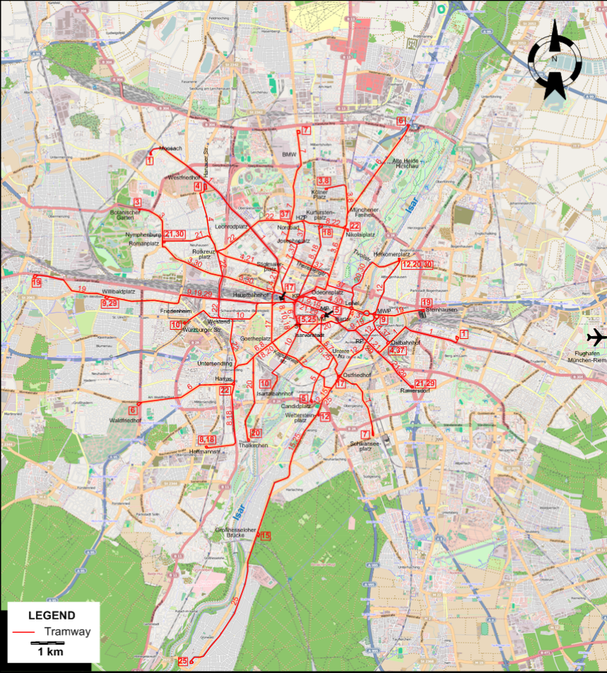
| 1 |
Berg am Laim - Ostbahnhof - Rosenheimer Platz - Isartor - Marienplatz - Karlsplatz - Hauptbahnhof (Main Station) -
Stiglmaierplatz - Leonrodplatz - Westfriedhof - Moosach |
| 3 |
Kölner Platz - Münchener Freiheit - Odeonsplatz - Karlsplatz - Hauptbahnhof (Main Station) - Nymphenburg (Romanplatz) - Botanischer Garten |
| 4 |
Ostbahnhof - Max-Weber-Platz - Lehel - Karlsplatz - Hauptbahnhof (Main Station) -
Stiglmaierplatz - Rotkreuzplatz - Neuhausen - Westfriedhof (Hanauer Str.) |
| 5 |
Viktualienmarkt - Untere Au - Candidplatz |
| 6 |
Freimann - Alte Heide-Hirschau - Münchener Freiheit - Odeonsplatz - Karlsplatz - Sendlinger Tor - Goetheplatz - Untersendling -
Harras - Waldfriedhof |
| 7 |
Milbertshofen - BMW - Nordbad - Josephsplatz - Hauptbahnhof (Main Station) - Karlsplatz - Sendlinger Tor - Isarvorstadt - Untere Au -
Ostfriedhof - Obergiesing - Schwanseeplatz |
| 8 |
Kölner Platz - Münchener Freiheit - Kurfürstenplatz - Karlsplatz - Sendlinger Tor - Goetheplatz - Untersendling -
Harras - Hoffmannstr. |
| 9 |
Max-Weber-Platz - Isartor - Marienplatz - Karlsplatz - Hauptbahnhof (Main Station) - Friedenheim - Willibaldplatz |
| 10 |
Isartalbahnhof - Isarvorstadt - Sendlinger Tor - Karlsplatz - Hauptbahnhof (Main Station) - Westend - Würzburger Str. |
| 12 |
Herkomerplatz - Max-Weber-Platz - Rosenheimer Platz - Ostfriedhof - Wettersteinplatz |
| 15 |
Karlsplatz - Sendlinger Tor - Isarvorstadt - Untere Au - Ostfriedhof - Wettersteinplatz - Giesing - Harlaching - Großhesseloher Brücke |
| 17 |
Hauptbahnhof (Main Station) - Goetheplatz - Kapuzinerstr. - Ostfriedhof |
| 18 |
Kurfürstenplatz - Karlsplatz - Sendlinger Tor - Goetheplatz - Untersendling - Harras - Hoffmannstr. |
| 19 |
Steinhausen - Max-Weber-Platz - Isartor - Marienplatz - Karlsplatz - Hauptbahnhof (Main Station) - Friedenheim - Willibaldplatz - Pasing |
| 20 |
Herkomerplatz - Tivolistr. - Lehel - Isartor - Isarvorstadt - Sendlinger Tor - Goetheplatz - Thalkirchen |
| 21 |
Ramersdorf - Rosenheimer Platz - Isartor - Marienplatz - Karlsplatz - Hauptbahnhof (Main Station) -
Stiglmaierplatz - Rotkreuzplatz - Neuhausen - Nymphenburg (Romanplatz)
|
| 22 |
Nikolaiplatz - Kurfürstenplatz - Hohenzollernplatz - Nordbad - Leonrodplatz - Rotkreuzplatz - Westend - Untersendling - Harras
|
| 25 |
Karlsplatz - Sendlinger Tor - Isarvorstadt - Untere Au - Ostfriedhof - Wettersteinplatz - Giesing - Harlaching -
Großhesseloher Brücke - Grünwald |
| 29 |
Ramersdorf - Rosenheimer Platz - Isartor - Marienplatz - Karlsplatz - Hauptbahnhof (Main Station) - Friedenheim - Willibaldplatz |
| 30 |
Herkomerplatz - Tivolistr. - Lehel - Karlsplatz - Hauptbahnhof (Main Station) - Nymphenburg (Romanplatz) |
| 37 |
Ostbahnhof - Max-Weber-Platz - Lehel - Theresienstr. - Josephsplatz - Hohenzollernplatz - Nordbad |