THE GS TRAM SITE

VANCOUVER

BRITISH COLUMBIA, CANADA

flag.ca

1952


CANADA

CALGARY

MONTRÉAL

OTTAWA

TORONTO

VANCOUVER

VICTORIA


GS Web Site Home


Vancouver tram map 1952


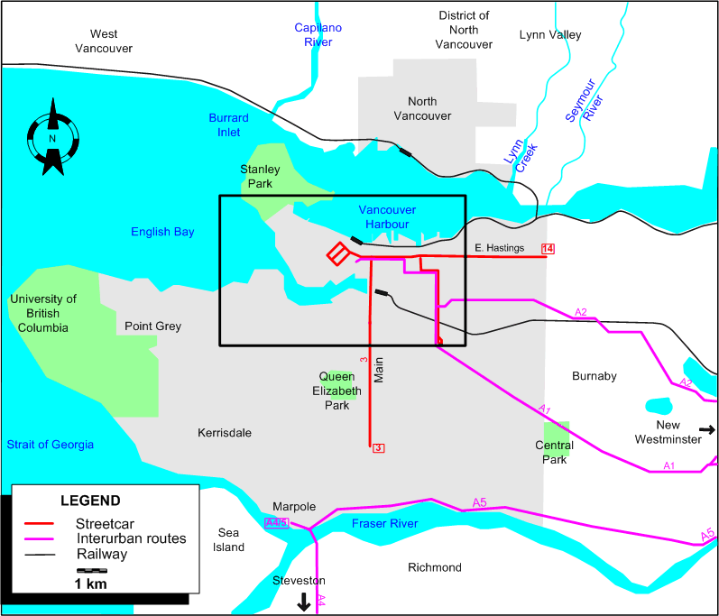
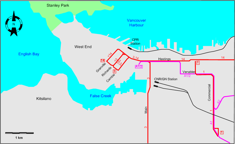
INSET: DOWNTOWN VANCOUVER

Vancouver downtown tram map 1949


ROUTES

Operator: British Columbia Electric Railway Company (BCER)

URBAN STREETCAR ROUTES (VANCOUVER)

  1 18th & Commercial - Commercial - Venables - Clark - Hastings & Clark
  3 50th & Main - Main - Hastings - Richards (back: Cambie) - Robson
14 Robson - Richards (back: Granville) - Hastings - Kootenay Loop

INTERURBAN ROUTES

A1 Hastings & Carrall - Central Park (Burnaby) - New Westminster
A2 Hastings & Carrall - Burnaby Lake - New Westminster
A4 Marpole - Richmond - Steveston
A5 Marpole - New Westminster

The following routes ceased operation between 1952 and 1955:

  • A1: 14 July 1954.
  • A2: 22 Oct. 1953.


CHARACTERISTICS OF THE SYSTEM

NETWORK LENGTH

  • Vancouver streetcar lines: ? km.
  • Interurban lines: ? km.


HISTORY

  • Vancouver streetcars: (electric) 28 June 1890 - 21 Apr. 1955.
  • North Vancouver streetcars: (electric) 1 Sept. 1906 - 23 Apr. 1947.
  • Interurban trams: (electric) 3 June 1891 - 28 Feb. 1958.
  • SkyTrain: 3 Jan. 1986 - today.

GAUGE

  • Vancouver streetcars: 1453 mm.
  • SkyTrain: 1435 mm.

SOURCES

PRINT

  • Conn, H. & Ewert, H. Vancouver's glory years: Public transit 1890-1915. North Vancouver: Whitecap Books, 2003.
  • "End of city trams in Vancouver" (news item), The Modern Tramway, July 1955 (18:211), p.142.
  • Ewert, H. The story of the B.C. Electric Railway Company. North Vancouver: Whitecap Books, 1986.
  • Transit System Map of Vancouver, B.C. [Vancouver]: Challengers Cartographers, 1949, 1952 and 1954.

WIKIS

WEB SITES


Hit count for this page: hit count

Valid HTML 4.01!


Copyright Gabor Sandi 1998-2008

To get in touch with the webmaster, send an e-mail to g_sandi@hotmail.com

Flags on this site are from the FOTW Flags Of The World website.