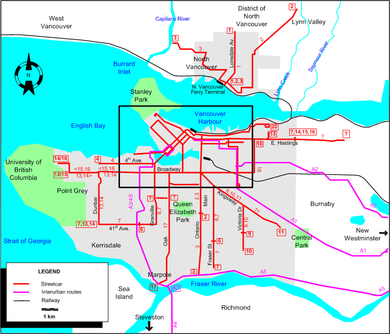
INSET: DOWNTOWN VANCOUVER
ROUTES
Operator: British Columbia Electric Railway Company (BCER)
URBAN STREETCAR ROUTES (VANCOUVER)
| 1 |
Granville - Broadway - Main - Hastings - Granville (circular route; both directions) |
| 2 |
Denman - Robson (back: Davie) - Granville - Cordova - Main - 33rd Ave. & Main |
| 3 |
Denman - Robson (back: Davie) - Granville - Cordova - Main - Fraser River (North Arm) |
| 4 |
18th & Commercial - Commercial - Venables - Clark - Hastings - Richards - Granville Bridge -
4th Ave. - 4th. & Alma |
| 5 |
Denman - Davie (back: Robson) - Granville - Hastings - Main - Broadway - Broadway & Findlay (just past Commercial) |
| 6 |
49th & Fraser - Fraser - Kingsway - Main - Cordova - Granville - 41st Ave. - Kerrisdale (West Boulevard) |
| 7 |
Marine Drive & Fraser - Fraser - Kingsway - Main - Cordova - Granville - 41st Ave. - 41st & Dunbar |
| 9 |
44th & Victoria - Victoria Dr. - Kingsway - Main - Powell - Cordova - Main Post Office (Hastings & Granville) |
| 10 |
54th & Victoria - Victoria Dr. - Kingsway - Main - Powell - Cordova - Granville - Pender - Georgia - Stanley Park |
| 11 |
Joyce Loop - Kingsway - Main - Powell - Cordova - Granville - Pender - Georgia - Stanley Park |
| 12 |
Downtown (Hastings) - Granville (back: Robson - Richards) - Granville - BCER Bridge - Kitsilano Loop |
| 13 |
(10th & Sasamat - 10th Ave. [this direction only]) / (41st & Dunbar - Dunbar) - Alma - Broadway - Granville -
Davie - Richards - Hastings - Renfrew - Dundas & Renfrew (Exhibition Park) |
| 14 |
(4th & Drummond - 4th Ave. - Sasamat - 10th Ave. [this direction only]) / (41st & Dunbar - Dunbar) - Alma - Broadway - Granville -
Davie - Richards - Hastings - Boundary & Hastings |
| 15 |
Boundary & Hastings - Hastings - Richards - Davie - Granville - Broadway - Alma - 10th Ave. - 10th & Sasamat [this direction only] |
| 16 |
Boundary & Hastings - Hastings - Richards - Davie - Granville - Broadway - Alma - 10th Ave. - Sasamat - 4th Ave. - 4th & Drummond [this direction only] |
| 17 |
Cambie & Hastings - Cambie - Broadway - Oak - Marine Drive & Oak |
| 18 |
Nanaimo & Hastings - Nanaimo - Broadway - Broadway & Findlay |
| 19 |
Downtown (Granville & Hastings) - Cordova (back: Hastings) - Cordova - Powell - Powell & Commercial |
| 20 |
Downtown (Granville & Hastings) - Cordova (back: Hastings) - Cordova - Powell - Dundas - Eton (back: McGill) - Kaslo |
| ? |
Francis & Victoria Dr. - Francis - Georgia - Main - Hastings - Cordova - Granville - Pender - Georgia - Stanley Park |
| ? |
Broadway & Oak - Oak - 16th Ave. - 16th & Main |
| ? |
25th & Granville - 25th Ave. (King Edward Ave.) - 25th & Oak |
| ? |
Hastings & Boundary - Hastings - Ellesmere (in Burnaby) |
NB: The last four routes have unknown route numbers.
URBAN STREETCAR ROUTES (NORTH VANCOUVER)
| 1 |
North Vancouver Ferry Terminal - Lonsdale - Windsor Rd. & Lonsdale |
| 2 |
North Vancouver Ferry Terminal - 1st Str. E.- Grand Blvd. - Lynn Valley Rd. - Dempsey Rd. |
| 3 |
North Vancouver Ferry Terminal - 1st Str. W - Mahon - Marine Dr. - Fell Ave. - 20th. Str. - 22nd Str. - Capilano River |
The last day of operation of street cars in North Vancouver was: 23 April 1947
INTERURBAN ROUTES
| A1 |
Hastings & Carrall - Central Park (Burnaby) - New Westminster |
| A2 |
Hastings & Carrall - Burnaby Lake - New Westminster |
| A3 |
Vancouver (Pacific & Richards) - Granville - Arbutus - Marpole |
| A4 |
Vancouver (Pacific & Richards) - Granville - Arbutus - Marpole - Richmond - Steveston |
| A5 |
Vancouver (Pacific & Richards) - Granville - Arbutus - Marpole - New Westminster |
NB: The route numbers given above are those used in a later source. It is possible that in 1940 the interurban routes had only names, not numbers.
CHARACTERISTICS OF THE SYSTEM
NETWORK LENGTH
- Vancouver streetcar lines: ? km.
- North Vancouver streetcar lines: 16.4 km.
- Interurban lines: ? km.
|