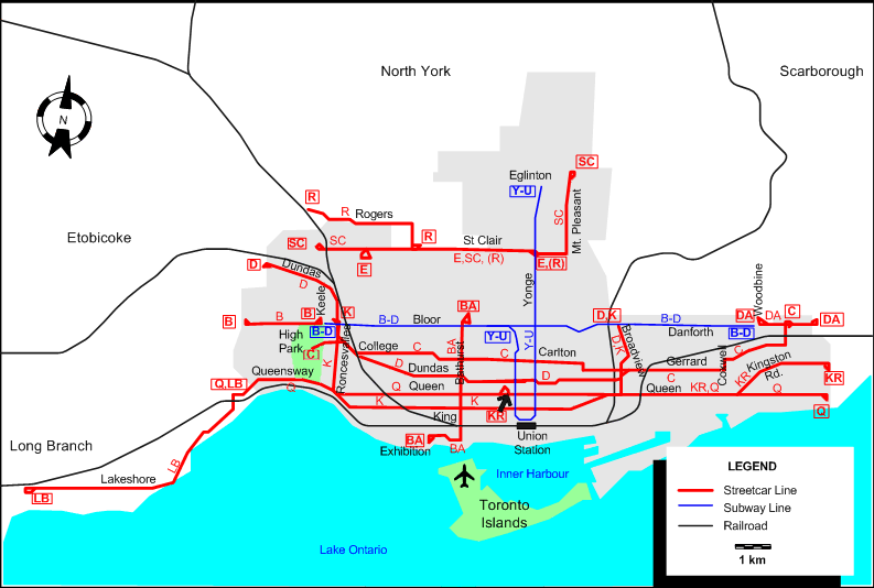
ROUTES
Operator: Toronto Transit Commission (TTC)
Note: The lettered route designations are of an indicative nature only, they were never used as such. The official names of the routes are given in the second column in capitals.
STREETCAR ROUTES
| B |
BLOOR SHUTTLE |
Jane & Bloor - Bloor St. - Keel Station |
| BA |
BATHURST |
Exhibition - Fleet St. - Bathurst St. - Bathurst & Bloor |
| C |
CARLTON |
Howard Park Ave. (High Park) - College St. - Carlton St. - Gerrard St. - Main St. - Main & Danforth |
| D |
DUNDAS |
Runnymede & Dundas - Dundas St. - Gerrard St. - Broadview Ave. - Broadview & Danforth |
| DA |
DANFORTH SHUTTLE |
Woodbine Station - Danforth Ave. - Victoria Park & Danforth |
| E |
EARLSCOURT |
Lansdowne & St. Clair - St Clair Ave. - Yonge & St. Clair |
| K |
KING |
Dundas W & Bloor - Roncesvalles Ave. - King St. - Queen St. - Broadview Ave. - Broadview & Danforth |
| KR |
KINGSTON ROAD |
McCaul Loop - Queen St. - Kingston Rd. - Victoria Park Ave. & Kingston Rd. (Bingham Loop) |
| LB |
LONG BRANCH |
Humber Loop - Lake Shore Blvd. - Long Branch |
| Q |
QUEEN |
Humber Loop - Queensway - Queen St. - Neville Park |
| R |
ROGERS ROAD |
Bicknell & Rogers Road - Rogers Road - Oakwood Ave. - Oakwood & St. Clair (- St. Clair Ave. - Yonge & St. Clair) |
| SC |
ST. CLAIR |
Keele & St. Clair - St. Clair Ave. - Mt. Pleasant Rd. - Mt. Pleasant & Eglinton |
SUBWAY ROUTES
| B-D |
BLOOR-DANFORTH |
Bloor & Keele - Bloor - Danforth - Danforth & Woodbine |
| Y-U |
YONGE-UNIVERSITY |
Eglinton - Yonge - Union Station - University - Bloor & St.George |
CHARACTERISTICS OF THE SYSTEM
NETWORK LENGTH
- Streetcars: ? km.
- Subway: ? km.
|