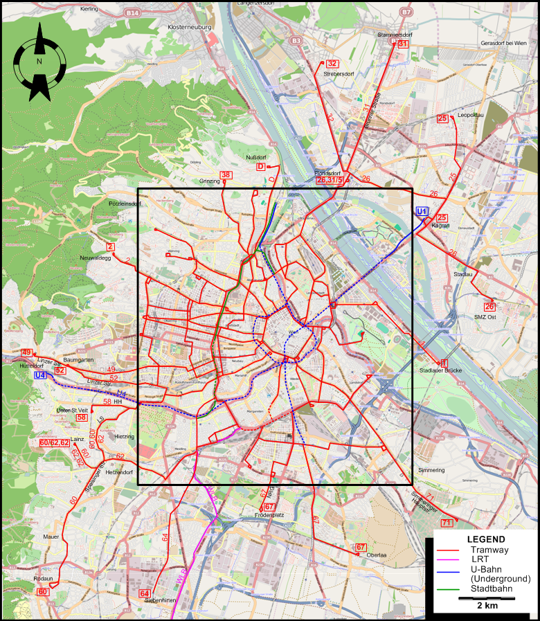
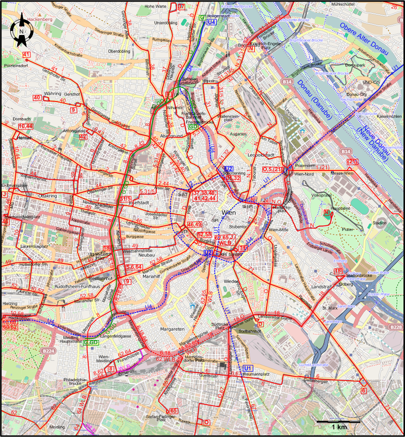
| D |
Nußdorf (Beethovengang) – Heiligenstädter Straße – Franz-Josefs-Bahnhof – Porzellangasse – Ring –
Prinz-Eugen-Straße – Südbahnhof |
| J |
Oper (Bösendorferstr.) – Ring – Josefstädter Straße – Neulerchenfelder Straße – Ottakringer Straße – Ottakring (Erdbrustgasse) |
| N |
Friedrich-Engels-Platz – Dresdner Straße – Taborstraße – Schwedenplatz – Radetzkyplatz - Prater-Hauptallee |
| O |
Praterstern – Franzensbrücke – Radetzkyplatz – Bahnhof Wien-Mitte – Ungargasse – Südbahnhof –
Wiedner Gürtel – Südtiroler Platz – Laxenburger Straße – Neilreichgasse - Raxstraße |
| 1 |
Praterkai - Messe-Wien - Praterstern - Taborstraße – Schwedenplatz - Stubentor – Schwarzenbergplatz – Oper – Volkstheater –
Schottentor – Schottenring – Franz-Josefs-Kai – Schwedenplatz - Taborstraße – Praterstern - Messe-Wien - Praterkai [Loop service, clockwise] |
| 2 |
Neuwaldegg - Dornbach – Hernalser Hauptstraße – Jörgerstraße – Alser Straße – Schottentor – Volkstheater – Oper – Schwarzenbergplatz –
Stubentor - Schwedenplatz - Franz-Josefs-Kai – Schottenring Schottentor – Alser Straße – Jörgerstraße – Hernalser Hauptstraße – Dornbach – Neuwaldegg [Loop service, counterclockwise] |
| 5 |
Westbahnhof – Kaiserstraße – Spitalgasse – Franz-Josefs-Bahnhof – Friedensbrücke - Wallensteinplatz – Am Tabor – Nordbahnstraße –
Praterstern |
| 6 |
Westbahnhof – Mariahilfer Gürtel - Margaretengürtel – Matzleinsdorfer Platz –
Quellenstraße – Reumannplatz - Geiselbergstraße – Simmeringer Hauptstraße |
| 8 |
Liechtenwerder Platz – Währinger Gürtel – Westbahnhof – Ullmannstraße – Wien-Meidling |
| 9 |
Mariahilfer Gürtel - Westbahnhof – Urban-Loritz-Platz – Märzstraße – Schweglerstraße – Feßtgasse – Hormayrgasse –
Kreuzgasse – Simonygasse – Gersthof (Wallrißstraße) |
| 10 |
Dornbach (Güpferlingstraße) – Sandleitengasse – Ottakring – Maroltingergasse – Joachimsthalerplatz –
Laurentiusplatz – Linzer Straße – Schloßallee – Hadikgasse – Hietzing (Kennedybrücke) |
| 18 |
Urban-Loritz-Platz – Westbahnhof – Margaretengürtel – Wiedner Gürtel –
Südtiroler Platz – Südbahnhof – Landstraßer Gürtel – St. Marx – Erdberg - Stadionbrücke |
| 21 |
Praterstern - Messe-Wien [Only during exhibitions] |
| 25 |
Kagran – Leopoldau |
| 26 |
Stadlau, SMZ Ost - Stadlau – Kagran –
Floridsdorf |
| 31 |
Schottenring – Augarten – Wexstraße – Stromstraße – Friedrich-Engels-Platz – Floridsdorfer Brücke – Floridsdorf – Brünner Straße – Stammersdorf |
| 31/5 |
Josefstädter Straße – Spitalgasse – Franz-Josefs-Bahnhof – Friedensbrücke - Wallensteinplatz – Jägerstraße – Stromstraße – Friedrich-Engels-Platz – Floridsdorfer Brücke – Floridsdorf [Weekday service only] |
| 32 |
Schottenring – Augarten – Jägerstraße – Stromstraße – Friedrich-Engels-Platz – Floridsdorfer Brücke – Floridsdorf – Strebersdorf (Edmund-Hawranek-Platz) |
| 37 |
Schottentor – Währinger Straße – Nußdorfer Straße – Döblinger Hauptstraße – Hohe Warte |
| 38 |
Schottentor – Währinger Straße – Nußdorfer Straße – Billrothstraße – Grinzinger Allee – Grinzing |
| 40 |
Schottentor – Währinger Straße – Gentzgasse – Herbeckstraße – Gersthof - Währing |
| 41 |
Schottentor – Währinger Straße – Gentzgasse – Gersthofer Straße – Pötzleinsdorfer Straße – Pötzleinsdorf |
| 42 |
Schottentor – Währinger Straße – Kreuzgasse – Antonigasse |
| 44 |
Schottentor – Alser Straße – Ottakringer Straße – Wilhelminenstraße – Sandleitengasse – Dornbach (Güpferlingstraße) |
| 46 |
Dr.-Karl-Renner-Ring (Volkstheater) – Lerchenfelder Straße – Thaliastraße – Maroltingergasse – Joachimsthalerplatz |
| 49 |
Dr.-Karl-Renner-Ring (Volkstheater) – Westbahnstraße – Märzstraße – Hütteldorfer Straße – Penzing -
Baumgarten – Linzer Straße – Hütteldorf |
| 52 |
Burgring - Mariahilfer Straße - Westbahnhof – Mariahilfer Straße – Linzer Straße – Baumgarten |
| 58 |
Burgring - Mariahilfer Straße - Westbahnhof – Mariahilfer Straße – Hadikgasse – Hietzing (Kennedybrücke) – Hietzinger Hauptstraße – Unter-St.Veit (Hummelgasse) |
| 60 |
Hietzing (Kennedybrücke) – Lainzer Straße – Speisinger Straße – Mauer – Rodaun |
| 60/62 |
Hietzing (Kennedybrücke) – Lainzer Straße – Speisinger Straße – Lainz |
| 62 |
Kärnter Ring, Oper – Wiedner Hauptstraße – Margaretengürtel – Flurschützstraße – Meidling - Hetzendorf – Speisinger Straße – Lainz |
| 64 |
Westbahnhof – Mariahilfer Gürtel - Flurschützstraße – Philadelphiabrücke – Siebenhirten |
| 65 |
Kärnter Ring, Oper – Wiedner Hauptstraße – Margaretengürtel – Knöllgasse – Stefan-Fadinger-Platz |
| 67 |
Frödenplatz – Neilreichgasse – Laxenburger Straße – Quellenstraße – Reumannplatz - Favoritenstraße – Oberlaa (Kurzentrum) |
| 71 |
Schwarzenbergplatz – Rennweg – St. Marx – Simmeringer Hauptstraße – Zentralfriedhof |